
Topografische Karte Vilaller
Klicken Sie auf die Karte, um die Höhe anzuzeigen.
Über diese Karte
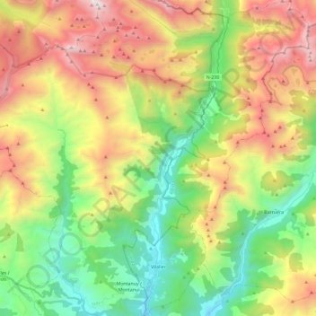
Name: Topografische Karte Vilaller, Höhe, Relief.
Ort: Vilaller, Alta Ribagorça, Lleida, Catalonia, 25552, Spain (42.44928 0.69049 42.61948 0.82632)
Durchschnittliche Höhe: 1.845 m
Minimale Höhe: 918 m
Maximale Höhe: 3.207 m
Andere topografische Karten
Klicken Sie auf eine Karte, um ihre Topografie, ihre Höhe und ihr Relief anzuzeigen.
Taüll
Spain > Catalonia > Alta Ribagorça > la Vall de Boí
Located at an altitude of 1,520 meters in the Sant Martí valley, a small valley in the Valley of Boí. The closest river is the Sant Martí river, Noguera de Tor affluent. A ravine splits the village in two districts: La Guinsa and Lo Barri. La Guinsa goes from the entrance of the village to the ravine, and…
Durchschnittliche Höhe: 1.707 m