
Vielen Dank für die Unterstützung dieser Website ❤️
Spenden
Spenden
Topografische Karte Taüll
Klicken Sie auf die Karte, um die Höhe anzuzeigen.
Vielen Dank für die Unterstützung dieser Website ❤️
Spenden
Spenden
Taüll
Located at an altitude of 1,520 meters in the Sant Martí valley, a small valley in the Valley of Boí. The closest river is the Sant Martí river, Noguera de Tor affluent. A ravine splits the village in two districts: La Guinsa and Lo Barri. La Guinsa goes from the entrance of the village to the ravine, and Lo Barri goes from the ravine to the high part of the village.
Vielen Dank für die Unterstützung dieser Website ❤️
Spenden
Spenden
Über diese Karte
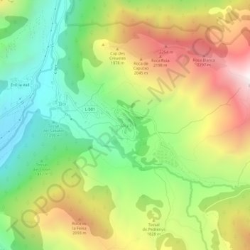
Name: Topografische Karte Taüll, Höhe, Relief.
Durchschnittliche Höhe: 1.707 m
Minimale Höhe: 1.115 m
Maximale Höhe: 2.498 m
Vielen Dank für die Unterstützung dieser Website ❤️
Spenden
Spenden