Geolokalisieren

Topografische Karte Grayson County

Interaktive Karte

Klicken Sie auf die Karte, um die Höhe anzuzeigen.

Über diese Karte

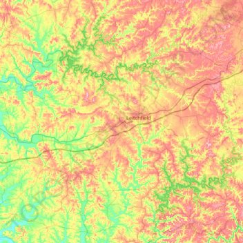
Name: Topografische Karte Grayson County, Höhe, Relief.

Ort: Grayson County, Kentucky, USA (37.32081 -86.66849 37.62244 -86.01900)

Durchschnittliche Höhe: 196 m

Minimale Höhe: 121 m

Maximale Höhe: 288 m

Andere topografische Karten

Klicken Sie auf eine Karte, um ihre Topografie, ihre Höhe und ihr Relief anzuzeigen.

Corbin

USA > Kentucky > Corbin

Corbin, Whitley County, Kentucky, USA

Durchschnittliche Höhe: 360 m

Westwood

USA > Kentucky > Westwood

Westwood, Jefferson County, Kentucky, USA

Durchschnittliche Höhe: 196 m

Madisonville

USA > Kentucky > Madisonville

Madisonville, Hopkins County, Kentucky, 42431, USA

Durchschnittliche Höhe: 136 m

Stringtown

USA > Kentucky > Stringtown

Stringtown, Boone County, Kentucky, 45233, USA

Durchschnittliche Höhe: 215 m

Robertson County

USA > Kentucky

Robertson County, Kentucky, 41064, USA

Durchschnittliche Höhe: 239 m

Adair County

USA > Kentucky

Adair County, Kentucky, USA

Durchschnittliche Höhe: 258 m

Music

USA > Kentucky > Music

Music, Carter County, Kentucky, USA

Durchschnittliche Höhe: 264 m

Bell County

USA > Kentucky

Bell County, Kentucky, USA

Durchschnittliche Höhe: 498 m

Pye

USA > Kentucky > Pye

Pye, Kenton County, Kentucky, 41015, USA

Durchschnittliche Höhe: 210 m

Ulysses

USA > Kentucky > Ulysses

Ulysses, Lawrence County, Kentucky, 41264, USA

Durchschnittliche Höhe: 238 m