Geolokalisieren

Topografische Karte Adair County

Interaktive Karte

Klicken Sie auf die Karte, um die Höhe anzuzeigen.

Über diese Karte

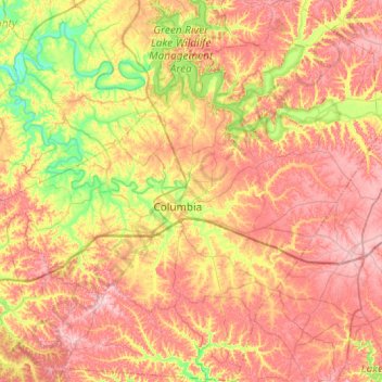
Name: Topografische Karte Adair County, Höhe, Relief.

Ort: Adair County, Kentucky, USA (36.92544 -85.52709 37.31203 -85.04304)

Durchschnittliche Höhe: 258 m

Minimale Höhe: 164 m

Maximale Höhe: 345 m

Andere topografische Karten

Klicken Sie auf eine Karte, um ihre Topografie, ihre Höhe und ihr Relief anzuzeigen.

Corbin

USA > Kentucky > Corbin

Corbin, Whitley County, Kentucky, USA

Durchschnittliche Höhe: 360 m

Westwood

USA > Kentucky > Westwood

Westwood, Jefferson County, Kentucky, USA

Durchschnittliche Höhe: 196 m

Madisonville

USA > Kentucky > Madisonville

Madisonville, Hopkins County, Kentucky, 42431, USA

Durchschnittliche Höhe: 136 m

Stringtown

USA > Kentucky > Stringtown

Stringtown, Boone County, Kentucky, 45233, USA

Durchschnittliche Höhe: 215 m

Robertson County

USA > Kentucky

Robertson County, Kentucky, 41064, USA

Durchschnittliche Höhe: 239 m

Music

USA > Kentucky > Music

Music, Carter County, Kentucky, USA

Durchschnittliche Höhe: 264 m

Bell County

USA > Kentucky

Bell County, Kentucky, USA

Durchschnittliche Höhe: 498 m

Pye

USA > Kentucky > Pye

Pye, Kenton County, Kentucky, 41015, USA

Durchschnittliche Höhe: 210 m

Ulysses

USA > Kentucky > Ulysses

Ulysses, Lawrence County, Kentucky, 41264, USA

Durchschnittliche Höhe: 238 m

Grayson County

USA > Kentucky

Grayson County, Kentucky, USA

Durchschnittliche Höhe: 196 m