
Topografische Karte Welda
Interaktive Karte
Klicken Sie auf die Karte, um die Höhe anzuzeigen.
Über diese Karte
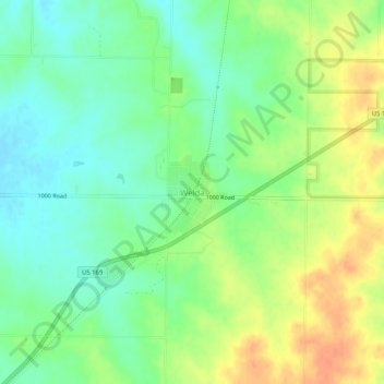
Name: Topografische Karte Welda, Höhe, Relief.
Ort: Welda, Anderson County, Kansas, 66091, United States (38.14964 -95.31483 38.18964 -95.27483)
Durchschnittliche Höhe: 339 m
Minimale Höhe: 321 m
Maximale Höhe: 361 m
Andere topografische Karten
Klicken Sie auf eine Karte, um ihre Topografie, ihre Höhe und ihr Relief anzuzeigen.
Colony
United States > Kansas > Anderson County
Colony, Anderson County, Kansas, United States
Durchschnittliche Höhe: 339 m
Greeley
United States > Kansas > Anderson County
Greeley, Anderson County, Kansas, United States
Durchschnittliche Höhe: 279 m
Westphalia
United States > Kansas > Anderson County
Westphalia, Anderson County, Kansas, United States
Durchschnittliche Höhe: 336 m
Lone Elm
United States > Kansas > Anderson County
Lone Elm, Anderson County, Kansas, United States
Durchschnittliche Höhe: 337 m
Kincaid
United States > Kansas > Anderson County
Kincaid, Anderson County, Kansas, United States
Durchschnittliche Höhe: 319 m
Garnett
United States > Kansas > Anderson County
Garnett, Anderson County, Kansas, United States
Durchschnittliche Höhe: 320 m
Garnett
United States > Kansas > Anderson County > Garnett
Garnett, Anderson County, Kansas, 66032, United States
Durchschnittliche Höhe: 313 m