
Topografische Karte Greeley
Interaktive Karte
Klicken Sie auf die Karte, um die Höhe anzuzeigen.
Über diese Karte
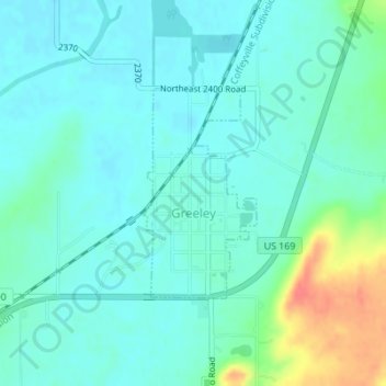
Name: Topografische Karte Greeley, Höhe, Relief.
Ort: Greeley, Anderson County, Kansas, United States (38.36071 -95.13142 38.37540 -95.12129)
Durchschnittliche Höhe: 279 m
Minimale Höhe: 266 m
Maximale Höhe: 323 m
Andere topografische Karten
Klicken Sie auf eine Karte, um ihre Topografie, ihre Höhe und ihr Relief anzuzeigen.
Colony
United States > Kansas > Anderson County
Colony, Anderson County, Kansas, United States
Durchschnittliche Höhe: 339 m
Welda
United States > Kansas > Anderson County
Welda, Anderson County, Kansas, 66091, United States
Durchschnittliche Höhe: 339 m
Westphalia
United States > Kansas > Anderson County
Westphalia, Anderson County, Kansas, United States
Durchschnittliche Höhe: 336 m
Lone Elm
United States > Kansas > Anderson County
Lone Elm, Anderson County, Kansas, United States
Durchschnittliche Höhe: 337 m
Kincaid
United States > Kansas > Anderson County
Kincaid, Anderson County, Kansas, United States
Durchschnittliche Höhe: 319 m
Garnett
United States > Kansas > Anderson County
Garnett, Anderson County, Kansas, United States
Durchschnittliche Höhe: 320 m
Garnett
United States > Kansas > Anderson County > Garnett
Garnett, Anderson County, Kansas, 66032, United States
Durchschnittliche Höhe: 313 m