
Spenden
Topografische Karte Tarlac City
Klicken Sie auf die Karte, um die Höhe anzuzeigen.
Spenden
Über diese Karte
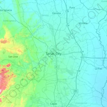
Name: Topografische Karte Tarlac City, Höhe, Relief.
Ort: Tarlac City, Tarlac, Central Luzon, Philippines (15.32612 120.42935 15.64612 120.74935)
Durchschnittliche Höhe: 56 m
Minimale Höhe: 13 m
Maximale Höhe: 376 m
Spenden
Andere topografische Karten
Klicken Sie auf eine Karte, um ihre Topografie, ihre Höhe und ihr Relief anzuzeigen.
Camiling
Mostly of plain topography but some parts are hilly to mountainous in which the barangays of Papaac, Bacsay, Birbira and Cayasan, to name a few. The deeper part of the mountains can be described as a place where wild animals live, such as deer, Toddy cat (Musang), wild boar (Baboy ramo), Monitor lizard…
Durchschnittliche Höhe: 32 m
Spenden
Pura
Pura, just like any other town in the province of the Tarlac has two (2) pronounced seasons. The wet season that starts from May up to lasts up to September and dry from the month of October to April. This type of climate is typically hot, humid, and tropical and is generally affected by the neighboring…
Durchschnittliche Höhe: 23 m
Spenden
Spenden
Spenden
Spenden
Spenden
Spenden
Spenden
Spenden
Spenden
Spenden
Pura
Pura, just like any other town in the province of the Tarlac has two (2) pronounced seasons. The wet season that starts from May up to lasts up to September and dry from the month of October to April. This type of climate is typically hot, humid, and tropical and is generally affected by the neighboring…
Durchschnittliche Höhe: 23 m
Spenden
Spenden
Camiling
Mostly of plain topography but some parts are hilly to mountainous in which the barangays of Papaac, Bacsay, Birbira and Cayasan, to name a few. The deeper part of the mountains can be described as a place where wild animals live, such as deer, Toddy cat (Musang), wild boar (Baboy ramo), Monitor lizard…
Durchschnittliche Höhe: 32 m
Spenden
Spenden