
Topografische Karte Douglas County
Interaktive Karte
Klicken Sie auf die Karte, um die Höhe anzuzeigen.
Über diese Karte
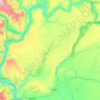
Name: Topografische Karte Douglas County, Höhe, Relief.
Ort: Douglas County, Washington, United States of America (47.22005 -120.31808 48.15019 -118.95272)
Durchschnittliche Höhe: 634 m
Minimale Höhe: 171 m
Maximale Höhe: 2.318 m
Andere topografische Karten
Klicken Sie auf eine Karte, um ihre Topografie, ihre Höhe und ihr Relief anzuzeigen.
East Renton Highlands
United States of America > Washington > East Renton Highlands > East Renton Highlands
East Renton Highlands, King County, Washington, United States of America
Durchschnittliche Höhe: 159 m
Clyde Hill
United States of America > Washington > Clyde Hill > Clyde Hill
Clyde Hill, King County, Washington, United States of America
Durchschnittliche Höhe: 48 m
Clark County
United States of America > Washington
Clark County, Washington, United States of America
Durchschnittliche Höhe: 266 m
Cedar Creek Falls
United States of America > Washington
Cedar Creek Falls, Clark County, Washington, United States of America
Durchschnittliche Höhe: 440 m
Bellingham
United States of America > Washington > Bellingham
Bellingham, Whatcom County, Washington, United States of America
Durchschnittliche Höhe: 89 m
Christmas Creek
United States of America > Washington
Christmas Creek, Jefferson County, Washington, United States of America
Durchschnittliche Höhe: 242 m
Western Junction
United States of America > Washington > Western Junction
Western Junction, Thurston County, Washington, United States of America
Durchschnittliche Höhe: 114 m
Danville
United States of America > Washington > Maple Valley > Danville
Danville, Maple Valley, King County, Washington, 98038, United States of America
Durchschnittliche Höhe: 174 m
Duvall
United States of America > Washington > Duvall
Duvall, King County, Washington, United States of America
Durchschnittliche Höhe: 50 m
Cheney
United States of America > Washington > Cheney
Cheney, Spokane County, Washington, 99024, United States of America
Durchschnittliche Höhe: 725 m
Alice Creek
United States of America > Washington
Alice Creek, King County, Washington, United States of America
Durchschnittliche Höhe: 999 m
Bellevue
United States of America > Washington > Bellevue
Bellevue, King County, Washington, 98004-4452, United States of America
Durchschnittliche Höhe: 88 m
West Kelso
United States of America > Washington > Kelso > West Kelso
West Kelso, Kelso, Cowlitz County, Washington, 98626, United States of America
Durchschnittliche Höhe: 26 m
Mount Lindsay
United States of America > Washington
Mount Lindsay, King County, Washington, United States of America
Durchschnittliche Höhe: 1.065 m
Mac's Cove
United States of America > Washington > Cornet
Mac's Cove, Discovery Trail, Cornet, Island County, Washington, United States of America
Durchschnittliche Höhe: 25 m
Cathcart
United States of America > Washington > Cathcart
Cathcart, Snohomish County, Washington, 98296, United States of America
Durchschnittliche Höhe: 105 m
Deception Pass
United States of America > Washington > Rosario Beach
Deception Pass, Deception Pass Bridge, Deception Pass Shores, Rosario Beach, Skagit County, Washington, 98221, United States of America
Durchschnittliche Höhe: 28 m
Tukwila
United States of America > Washington > Tukwila
Tukwila, King County, Washington, United States of America
Durchschnittliche Höhe: 59 m
Walla Walla
United States of America > Washington > Walla Walla
Walla Walla, Walla Walla County, Washington, United States of America
Durchschnittliche Höhe: 297 m