
Topografische Karte Clark County
Interaktive Karte
Klicken Sie auf die Karte, um die Höhe anzuzeigen.
Über diese Karte
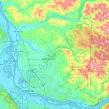
Name: Topografische Karte Clark County, Höhe, Relief.
Ort: Clark County, Washington, United States of America (45.54372 -122.79625 46.05972 -122.24453)
Durchschnittliche Höhe: 266 m
Minimale Höhe: -3 m
Maximale Höhe: 1.318 m
Many lakes border the river in the lowlands near Ridgefield, including Vancouver Lake. Eastern and northern Clark County contain forested foothills of the Cascade Mountains, rising to an elevation of 4,000 feet (1,200 m) on the border with Skamania County. Larch Mountain is the county's highest free-standing peak.
Andere topografische Karten
Klicken Sie auf eine Karte, um ihre Topografie, ihre Höhe und ihr Relief anzuzeigen.
East Renton Highlands
United States of America > Washington > East Renton Highlands > East Renton Highlands
East Renton Highlands, King County, Washington, United States of America
Durchschnittliche Höhe: 159 m
Clyde Hill
United States of America > Washington > Clyde Hill > Clyde Hill
Clyde Hill, King County, Washington, United States of America
Durchschnittliche Höhe: 48 m
Cedar Creek Falls
United States of America > Washington
Cedar Creek Falls, Clark County, Washington, United States of America
Durchschnittliche Höhe: 440 m
Douglas County
United States of America > Washington
Douglas County, Washington, United States of America
Durchschnittliche Höhe: 634 m
Bellingham
United States of America > Washington > Bellingham
Bellingham, Whatcom County, Washington, United States of America
Durchschnittliche Höhe: 89 m
Christmas Creek
United States of America > Washington
Christmas Creek, Jefferson County, Washington, United States of America
Durchschnittliche Höhe: 242 m
Western Junction
United States of America > Washington > Western Junction
Western Junction, Thurston County, Washington, United States of America
Durchschnittliche Höhe: 114 m
Danville
United States of America > Washington > Maple Valley > Danville
Danville, Maple Valley, King County, Washington, 98038, United States of America
Durchschnittliche Höhe: 174 m
Cheney
United States of America > Washington > Cheney
Cheney, Spokane County, Washington, 99024, United States of America
Durchschnittliche Höhe: 725 m
Alice Creek
United States of America > Washington
Alice Creek, King County, Washington, United States of America
Durchschnittliche Höhe: 999 m
Bellevue
United States of America > Washington > Bellevue
Bellevue, King County, Washington, 98004-4452, United States of America
Durchschnittliche Höhe: 88 m
West Kelso
United States of America > Washington > Kelso > West Kelso
West Kelso, Kelso, Cowlitz County, Washington, 98626, United States of America
Durchschnittliche Höhe: 26 m
Mount Lindsay
United States of America > Washington
Mount Lindsay, King County, Washington, United States of America
Durchschnittliche Höhe: 1.065 m
Mac's Cove
United States of America > Washington > Cornet
Mac's Cove, Discovery Trail, Cornet, Island County, Washington, United States of America
Durchschnittliche Höhe: 25 m
Cathcart
United States of America > Washington > Cathcart
Cathcart, Snohomish County, Washington, 98296, United States of America
Durchschnittliche Höhe: 105 m
Deception Pass
United States of America > Washington > Rosario Beach
Deception Pass, Deception Pass Bridge, Deception Pass Shores, Rosario Beach, Skagit County, Washington, 98221, United States of America
Durchschnittliche Höhe: 28 m
Tukwila
United States of America > Washington > Tukwila
Tukwila, King County, Washington, United States of America
Durchschnittliche Höhe: 59 m
Duvall
United States of America > Washington > Duvall
Duvall, King County, Washington, United States of America
Durchschnittliche Höhe: 50 m
Walla Walla
United States of America > Washington > Walla Walla
Walla Walla, Walla Walla County, Washington, United States of America
Durchschnittliche Höhe: 297 m