
Spenden
Topografische Karte Friedensdorf
Klicken Sie auf die Karte, um die Höhe anzuzeigen.
Spenden
Friedensdorf
Weitere Orte: Bagnica (Pagelsland) | Bartlewo | Chocimino Leśne | Chróstowo (Twelberg) | Chrustowo (Friedrichslust) | Czarnowiec (Tannenwalde) | Czyżewo (Pfingstberg) | Dalimierz (Johannishof) | Doły | Dzikowo | Gilewo (Wilhelmshof) | Głusza (Bärenlager) | Gosław (Arnsberg) | Gostkowo (Wilkenhof) | Jaromierz Polanowski (Ludwigshof) | Jeżewo | Kania | Karsina (Karzin, Kr. Köslin) | Kierzkowo (Grünheide) | Knieja | Komorowo (Kummerow, Kr. Schlawe) | Kopaniec (Althütte) | Kościerniczka (Neu Kösternitz) | Kwiecko | Lipki (Klein Linde) | Liszkowo | Łąkie (Schlosshof) | Łokwica (Hildegardshöhe) | Małomierz (Luisenhof) | Mirotki | Młyniska | Nadbór (Nadebahr) | Osetno | Piaskowo (Seekaten) | Pieczyska (Vorhütte) | Pokrzywno | Puławy (Neu Amerika) | Przybrodzie | Pyszki (Elsenthal) | Racibórz Polanowski (Heinrichshorst) | Racław (Ratzlaffenkamp) | Rzeczyca Mała (Klein Reetz) | Samostrzel (Neuhof) | Smugi (Thalhof) | Stare Wiatrowo (Alt Kleehof) | Stołpie (Kuhstolp) | Strzeżewo (Karlshof) | Szczerbin (Karlshof) | Trzebaw (Hasselhof) | Zagaje (Schonungshof) | Zdzieszewo | Żdżar (Sohrhof)
Spenden
Über diese Karte
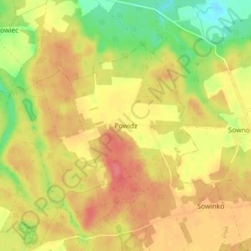
Name: Topografische Karte Friedensdorf, Höhe, Relief.
Durchschnittliche Höhe: 86 m
Minimale Höhe: 49 m
Maximale Höhe: 112 m
Spenden