
Spenden
Topografische Karte Cumberland
Klicken Sie auf die Karte, um die Höhe anzuzeigen.
Spenden
Über diese Karte
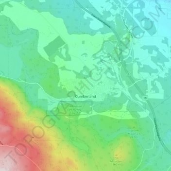
Name: Topografische Karte Cumberland, Höhe, Relief.
Durchschnittliche Höhe: 203 m
Minimale Höhe: 47 m
Maximale Höhe: 668 m
Spenden
Andere topografische Karten
Klicken Sie auf eine Karte, um ihre Topografie, ihre Höhe und ihr Relief anzuzeigen.
Fanny Bay
Canada > British Columbia > Comox Valley Regional District > Area A (Baynes Sound)
Durchschnittliche Höhe: 36 m
Dove Creek
Canada > British Columbia > Comox Valley Regional District > Area C (Puntledge/Black Creek)
Durchschnittliche Höhe: 42 m
Forbidden Plateau
Canada > British Columbia > Comox Valley Regional District > Area C (Puntledge/Black Creek)
Durchschnittliche Höhe: 1.041 m
Mount Washington
Canada > British Columbia > Comox Valley Regional District > Area C (Puntledge/Black Creek)
Durchschnittliche Höhe: 1.279 m
Spenden
Black Creek
Canada > British Columbia > Comox Valley Regional District > Area C (Puntledge/Black Creek)
Durchschnittliche Höhe: 60 m
Royston
Canada > British Columbia > Comox Valley Regional District > Area A (Baynes Sound)
Durchschnittliche Höhe: 29 m
Courtenay
Canada > British Columbia > Comox Valley Regional District > Courtenay
Durchschnittliche Höhe: 187 m
Union Bay
Canada > British Columbia > Comox Valley Regional District > Area A (Baynes Sound)
Durchschnittliche Höhe: 39 m
Spenden
Croteau Lake
Canada > British Columbia > Comox Valley Regional District > Area C (Puntledge/Black Creek)
Durchschnittliche Höhe: 1.195 m
Buckley Bay
Canada > British Columbia > Comox Valley Regional District > Area A (Baynes Sound)
Durchschnittliche Höhe: 35 m
Nymph Falls
Canada > British Columbia > Comox Valley Regional District > Area C (Puntledge/Black Creek)
Durchschnittliche Höhe: 128 m
Mount Albert Edward
Canada > British Columbia > Comox Valley Regional District > Area C (Puntledge/Black Creek)
Durchschnittliche Höhe: 1.508 m
Spenden
Waveland
Canada > British Columbia > Comox Valley Regional District > Area B (Lazo North)
Durchschnittliche Höhe: 38 m
Little River
Canada > British Columbia > Comox Valley Regional District > Area B (Lazo North)
Durchschnittliche Höhe: 13 m
Mount Becher
Canada > British Columbia > Comox Valley Regional District > Area C (Puntledge/Black Creek)
Durchschnittliche Höhe: 1.035 m
MacAulay Heights
Canada > British Columbia > Comox Valley Regional District > Area C (Puntledge/Black Creek)
Durchschnittliche Höhe: 94 m
Spenden
Miracle Beach
Canada > British Columbia > Comox Valley Regional District > Area C (Puntledge/Black Creek) > Miracle Beach
Durchschnittliche Höhe: 30 m
Oyster River
Canada > British Columbia > Comox Valley Regional District > Area C (Puntledge/Black Creek)
Durchschnittliche Höhe: 973 m
Beaufort Range
Canada > British Columbia > Comox Valley Regional District > Area A (Baynes Sound)
Durchschnittliche Höhe: 435 m
Mount Curran
Canada > British Columbia > Comox Valley Regional District > Area A (Baynes Sound)
Durchschnittliche Höhe: 1.142 m
Spenden
Forbidden Plateau
Canada > British Columbia > Comox Valley Regional District > Area C (Puntledge/Black Creek)
Durchschnittliche Höhe: 650 m