
Spenden
Topografische Karte Croteau Lake
Klicken Sie auf die Karte, um die Höhe anzuzeigen.
Spenden
Über diese Karte
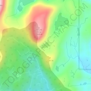
Name: Topografische Karte Croteau Lake, Höhe, Relief.
Durchschnittliche Höhe: 1.195 m
Minimale Höhe: 1.064 m
Maximale Höhe: 1.438 m
Spenden
Andere topografische Karten
Klicken Sie auf eine Karte, um ihre Topografie, ihre Höhe und ihr Relief anzuzeigen.
Dove Creek
Canada > British Columbia > Comox Valley Regional District > Area C (Puntledge/Black Creek)
Durchschnittliche Höhe: 42 m
Forbidden Plateau
Canada > British Columbia > Comox Valley Regional District > Area C (Puntledge/Black Creek)
Durchschnittliche Höhe: 1.041 m
Mount Washington
Canada > British Columbia > Comox Valley Regional District > Area C (Puntledge/Black Creek)
Durchschnittliche Höhe: 1.279 m
Black Creek
Canada > British Columbia > Comox Valley Regional District > Area C (Puntledge/Black Creek)
Durchschnittliche Höhe: 60 m
Spenden
Nymph Falls
Canada > British Columbia > Comox Valley Regional District > Area C (Puntledge/Black Creek)
Durchschnittliche Höhe: 128 m
Mount Albert Edward
Canada > British Columbia > Comox Valley Regional District > Area C (Puntledge/Black Creek)
Durchschnittliche Höhe: 1.508 m
Mount Becher
Canada > British Columbia > Comox Valley Regional District > Area C (Puntledge/Black Creek)
Durchschnittliche Höhe: 1.035 m
MacAulay Heights
Canada > British Columbia > Comox Valley Regional District > Area C (Puntledge/Black Creek)
Durchschnittliche Höhe: 94 m
Spenden
Miracle Beach
Canada > British Columbia > Comox Valley Regional District > Area C (Puntledge/Black Creek) > Miracle Beach
Durchschnittliche Höhe: 30 m
Forbidden Plateau
Canada > British Columbia > Comox Valley Regional District > Area C (Puntledge/Black Creek)
Durchschnittliche Höhe: 650 m