
Topografische Karte Tortosendo
Interaktive Karte
Klicken Sie auf die Karte, um die Höhe anzuzeigen.
Über diese Karte
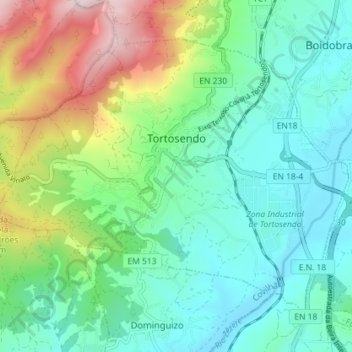
Name: Topografische Karte Tortosendo, Höhe, Relief.
Ort: Tortosendo, Covilhã, Castelo Branco, Portugal (40.21240 -7.55974 40.25514 -7.48823)
Durchschnittliche Höhe: 564 m
Minimale Höhe: 395 m
Maximale Höhe: 1.006 m
Andere topografische Karten
Klicken Sie auf eine Karte, um ihre Topografie, ihre Höhe und ihr Relief anzuzeigen.
Vila do Carvalho
Portugal > Castelo Branco > Covilhã
Vila do Carvalho, Covilhã, Castelo Branco, Portugal
Durchschnittliche Höhe: 1.073 m
Cantar-Galo
Portugal > Castelo Branco > Covilhã
Cantar-Galo, Cantar-Galo e Vila do Carvalho, Covilhã, Castelo Branco, 6200-405, Portugal
Durchschnittliche Höhe: 1.093 m
Casegas
Portugal > Castelo Branco > Covilhã
Casegas, Covilhã, Castelo Branco, 6230-661, Portugal
Durchschnittliche Höhe: 504 m
Unhais da Serra
Portugal > Castelo Branco > Covilhã
Unhais da Serra, Covilhã, Castelo Branco, Portugal
Durchschnittliche Höhe: 1.085 m