
Topografische Karte Teramo
Interaktive Karte
Klicken Sie auf die Karte, um die Höhe anzuzeigen.
Über diese Karte
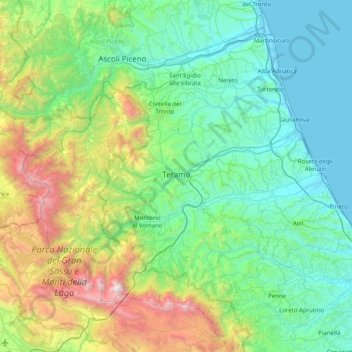
Name: Topografische Karte Teramo, Höhe, Relief.
Ort: Teramo, Abruzzo, Italy (42.42112 13.34693 42.89508 14.14632)
Durchschnittliche Höhe: 600 m
Minimale Höhe: -2 m
Maximale Höhe: 2.841 m
The landscape of the Province of Teramo is dominated almost entirely on the east by a large body of water with the beaches of the Adriatic sea and by the Apennine Mountains which his highest peak of Gran Sasso d'Italia westside. The province is indeed divided latitudinally by the characteristic hills and valleys rich in vineyards and olive groves that begin in the Apennines and run almost to the coast. Colline Teramane (Teramo Hills) has become a trademark and are one of the most significant areas where extra virgin olive oil and Abruzzo wines are produced. Unique of the province of Teramo is the short distance between the beaches of the Adriatic sea and the 3,000-metre (9,800 ft) snowcapped Gran Sasso peaks. They can be reached within an hour from one point to the other. The peaks of the Gran Sasso rise to the west of the Province of Teramo while those of the Monti della Laga dominate its northern border. These two ridges are among the most distinctive and the most relevant of the entire Apennine Mountain range. The majestic Gran Sasso rises at its peak, the Corno Grande, to an elevation of 2,912 metres (9,554 ft) and is characterized by steep, and in places virtually inaccessible, gorges with nature reserves and protected living species. A good part of Gran Sasso and Monti della Laga National Park is nestled in the province. Calderone, the southernmost glacier in Continental European, is found nearby. In contrast to the rugged and isolated Gran Sasso area, the Monti della Laga are characterised by thick forests, shallow gorges, rolling slopes and valleys, and several spectacular waterfalls. In addition to the provincial capital, the most populous and important commercial centers include Roseto degli Abruzzi and Giulianova with populations of 25,000 and 24,000 inhabitants respectively. On the eastern portion of the province are the so-called "seven sister" beaches directly adjacent to the Adriatic Sea. These resorts are noted for one of the highest blue flag beaches density, very fine white sand and their mild and wholesome Mediterranean climates which support a rich flora of palm, pine and oleander trees. Much of the province is hilly and very few large flat plains are to be found. Running from the west to the east are a number of valley streams and rivers which eventually empty into the Adriatic Sea. The province of Teramo can easily be reached by car or bus from Rome via the A24 highway and it is also connected to the A14 highway.
Andere topografische Karten
Klicken Sie auf eine Karte, um ihre Topografie, ihre Höhe und ihr Relief anzuzeigen.
Borgo San Lorenzo
Borgo San Lorenzo, Fossa, L'Aquila, Abruzzo, 67040, Italy
Durchschnittliche Höhe: 607 m
Mosciano Sant'Angelo
Mosciano Sant'Angelo, Teramo, Abruzzo, 64023, Italy
Durchschnittliche Höhe: 122 m
Colonnella
Colonnella, Unione dei Comuni della Val Vibrata, Teramo, Abruzzo, Italy
Durchschnittliche Höhe: 102 m
Villa Vomano
Italy > Abruzzo > Teramo > Teramo
Villa Vomano, Teramo, Abruzzo, 64039, Italy
Durchschnittliche Höhe: 201 m
Rocca di Mezzo
Rocca di Mezzo, L'Aquila, Abruzzo, Italy
Durchschnittliche Höhe: 1.354 m
Spiaggia di Ripari Bardella
Italy > Abruzzo > Chieti > Ortona
Spiaggia di Ripari Bardella, Ripari, Ortona, Chieti, Abruzzo, Italy
Durchschnittliche Höhe: 29 m
Fontecchio
Fontecchio, L'Aquila, Abruzzo, Italy
Durchschnittliche Höhe: 867 m
Castelvecchio Calvisio
Castelvecchio Calvisio, L'Aquila, Abruzzo, Italy
Durchschnittliche Höhe: 1.289 m
Castel di Ieri
Castel di Ieri, L'Aquila, Abruzzo, Italy
Durchschnittliche Höhe: 767 m
Isola del Gran Sasso d'Italia
Isola del Gran Sasso d'Italia, Teramo, Abruzzo, 64045, Italy
Durchschnittliche Höhe: 994 m
Villa Santa Lucia degli Abruzzi
Villa Santa Lucia degli Abruzzi, L'Aquila, Abruzzo, Italy
Durchschnittliche Höhe: 1.098 m
Martinsicuro
Martinsicuro, Unione dei Comuni della Val Vibrata, Teramo, Abruzzo, 64014, Italy
Durchschnittliche Höhe: 39 m
Roccamorice
Italy > Abruzzo > Pescara > Roccamorice
Roccamorice, Pescara, Abruzzo, Italy
Durchschnittliche Höhe: 707 m
Torre de' Passeri
Italy > Abruzzo > Pescara > Torre de' Passeri
Torre de' Passeri, Pescara, Abruzzo, 65029, Italy
Durchschnittliche Höhe: 250 m
Montesilvano
Italy > Abruzzo > Montesilvano
Montesilvano, Pescara, Abruzzo, 65015, Italy
Durchschnittliche Höhe: 47 m
Costa d'Orsa
Italy > Abruzzo > Pratola Peligna > Costa d'Orsa
Costa d'Orsa, Pratola Peligna, L'Aquila, Abruzzo, 67035, Italy
Durchschnittliche Höhe: 354 m
Pescocostanzo
Pescocostanzo, L'Aquila, Abruzzo, 67033, Italy
Durchschnittliche Höhe: 1.448 m
Monte Rotella
Monte Rotella, Rocca Pia, L'Aquila, Abruzzo, Italy
Durchschnittliche Höhe: 1.741 m
Guardiagrele
Guardiagrele, Chieti, Abruzzo, 66016, Italy
Durchschnittliche Höhe: 534 m
Villa Rosa
Italy > Abruzzo > Martinsicuro > Villa Rosa
Villa Rosa, Martinsicuro, Teramo, Abruzzo, 64014, Italy
Durchschnittliche Höhe: 22 m
Gran Sasso d'Italia
Italy > Abruzzo > Isola del Gran Sasso d'Italia
Gran Sasso d'Italia, Ferrata Ricci, Isola del Gran Sasso d'Italia, TE, Abruzzo, 64047, Italy
Durchschnittliche Höhe: 1.976 m
Giulianova
Italy > Abruzzo > Giulianova
Giulianova, TE, Abruzzo, 64021, Italy
Durchschnittliche Höhe: 29 m
Colle Marino
Italy > Abruzzo > Colle Marino
Colle Marino, AQ, Abruzzo, 67049, Italy
Durchschnittliche Höhe: 905 m
Prati di Tivo
Prati di Tivo, Pietracamela, Teramo, Abruzzo, 64047, Italy
Durchschnittliche Höhe: 1.522 m
Caramanico Terme
Italy > Abruzzo > Caramanico Terme
Caramanico Terme, PE, Abruzzo, 65023, Italy
Durchschnittliche Höhe: 954 m