
Topografische Karte L'Aquila
Interaktive Karte
Klicken Sie auf die Karte, um die Höhe anzuzeigen.
Über diese Karte
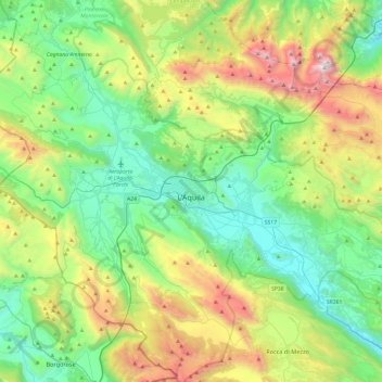
Name: Topografische Karte L'Aquila, Höhe, Relief.
Ort: L'Aquila, Abruzzo, Italy (42.17658 13.17723 42.53155 13.65410)
Durchschnittliche Höhe: 1.192 m
Minimale Höhe: 510 m
Maximale Höhe: 2.844 m
Close to the highest of the Apennine summits, L'Aquila is positioned at an elevation of 721 metres (2,365 ft) in the Valley of the Aterno-Pescara, situated between four mountain peaks above 2,000 metres (6,600 ft).
Andere topografische Karten
Klicken Sie auf eine Karte, um ihre Topografie, ihre Höhe und ihr Relief anzuzeigen.
Borgo San Lorenzo
Borgo San Lorenzo, Fossa, L'Aquila, Abruzzo, 67040, Italy
Durchschnittliche Höhe: 607 m
Rocca di Mezzo
Rocca di Mezzo, L'Aquila, Abruzzo, Italy
Durchschnittliche Höhe: 1.354 m
Fontecchio
Fontecchio, L'Aquila, Abruzzo, Italy
Durchschnittliche Höhe: 867 m
Castelvecchio Calvisio
Castelvecchio Calvisio, L'Aquila, Abruzzo, Italy
Durchschnittliche Höhe: 1.289 m
Castel di Ieri
Castel di Ieri, L'Aquila, Abruzzo, Italy
Durchschnittliche Höhe: 767 m
Villa Santa Lucia degli Abruzzi
Villa Santa Lucia degli Abruzzi, L'Aquila, Abruzzo, Italy
Durchschnittliche Höhe: 1.098 m
Pescocostanzo
Pescocostanzo, L'Aquila, Abruzzo, 67033, Italy
Durchschnittliche Höhe: 1.448 m