Topografische Karte Waiparous
Interaktive Karte
Klicken Sie auf die Karte, um die Höhe anzuzeigen.
Über diese Karte
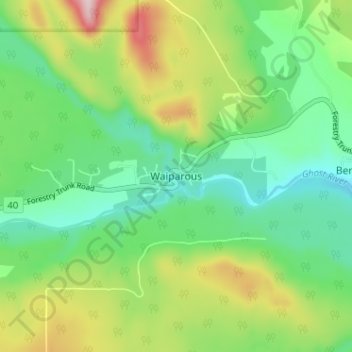
Name: Topografische Karte Waiparous, Höhe, Relief.
Ort: Waiparous, Municipal District of Bighorn, Alberta, Canada (51.26368 -114.85824 51.30368 -114.81824)
Durchschnittliche Höhe: 1.338 m
Minimale Höhe: 1.240 m
Maximale Höhe: 1.531 m
Andere topografische Karten
Klicken Sie auf eine Karte, um ihre Topografie, ihre Höhe und ihr Relief anzuzeigen.
Kananaskis
Canada > Alberta > Municipal District of Bighorn > Kananaskis
Kananaskis, Municipal District of Bighorn, Alberta, T0L 2C0, Canada
Durchschnittliche Höhe: 1.426 m
Gap Lake
Canada > Alberta > Municipal District of Bighorn
Gap Lake, Municipal District of Bighorn, Alberta, Canada
Durchschnittliche Höhe: 1.424 m
Exshaw
Canada > Alberta > Municipal District of Bighorn
Exshaw, Municipal District of Bighorn, Alberta, T0L 2C0, Canada
Durchschnittliche Höhe: 1.420 m
South Ghost Peak
Canada > Alberta > Municipal District of Bighorn
South Ghost Peak, Municipal District of Bighorn, Alberta, Canada
Durchschnittliche Höhe: 2.240 m
Dormer Mountain
Canada > Alberta > Municipal District of Bighorn
Dormer Mountain, Municipal District of Bighorn, Alberta, Canada
Durchschnittliche Höhe: 2.243 m