
Topografische Karte Gap Lake
Klicken Sie auf die Karte, um die Höhe anzuzeigen.
Über diese Karte
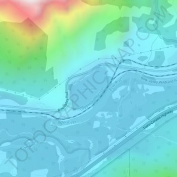
Name: Topografische Karte Gap Lake, Höhe, Relief.
Ort: Gap Lake, Municipal District of Bighorn, Alberta, Canada (51.05120 -115.23832 51.05782 -115.22819)
Durchschnittliche Höhe: 1.424 m
Minimale Höhe: 1.287 m
Maximale Höhe: 2.253 m
Andere topografische Karten
Klicken Sie auf eine Karte, um ihre Topografie, ihre Höhe und ihr Relief anzuzeigen.
Kananaskis
Canada > Alberta > Municipal District of Bighorn > Kananaskis
Durchschnittliche Höhe: 1.426 m
Whispering Pines Ranch
Canada > Alberta > Municipal District of Bighorn
Durchschnittliche Höhe: 1.426 m