
Spenden
Topografische Karte Les Bossons
Klicken Sie auf die Karte, um die Höhe anzuzeigen.
Spenden
Über diese Karte
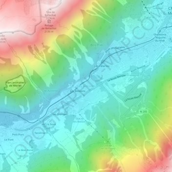
Name: Topografische Karte Les Bossons, Höhe, Relief.
Durchschnittliche Höhe: 1.376 m
Minimale Höhe: 980 m
Maximale Höhe: 2.296 m
Spenden
Andere topografische Karten
Klicken Sie auf eine Karte, um ihre Topografie, ihre Höhe und ihr Relief anzuzeigen.
Mer de Glace
France > Auvergne-Rhône-Alpes > Upper Savoy > Chamonix-Mont-Blanc
The glacier lies above the Chamonix valley. The pressure within the ice is known to reach at least 30 atmospheres. The Mer de Glace can be considered as originating at an elevation of 2,100 metres (6,900 ft), just north of the Aiguille du Tacul, where it is formed by the confluence of the Glacier de Leschaux…
Durchschnittliche Höhe: 2.323 m
Mer de Glace
France > Auvergne-Rhône-Alpes > Upper Savoy > Chamonix-Mont-Blanc
The glacier lies above the Chamonix valley. The pressure within the ice is known to reach at least 30 atmospheres. The Mer de Glace can be considered as originating at an elevation of 2,100 metres (6,900 ft), just north of the Aiguille du Tacul [fr], where it is formed by the confluence of the Glacier de…
Durchschnittliche Höhe: 2.322 m
Réserve naturelle des Aiguilles rouges
France > Auvergne-Rhône-Alpes > Upper Savoy > Chamonix-Mont-Blanc
Durchschnittliche Höhe: 1.951 m
Glacier des Bossons
France > Auvergne-Rhône-Alpes > Upper Savoy > Chamonix-Mont-Blanc
In 1900 the snout of the glacier was still reaching down into the valley bottom at an altitude of 1,050 metres above sea level. By 1980 the snout only reached down to about 1,200 metres, and by 2008 it had melted backwards even further backwards, ended at around 1,400 metres, albeit still well below the…
Durchschnittliche Höhe: 3.138 m
Spenden
Lac Blanc
France > Auvergne-Rhône-Alpes > Upper Savoy > Chamonix-Mont-Blanc
Durchschnittliche Höhe: 2.350 m