Geolokalisieren
👉 Easily get elevation data in JSON, GeoTIFF and KML formats using Elevation API
Vielen Dank für die Unterstützung dieser Website ❤️
Spenden

Topografische Karte Columbia

Klicken Sie auf die Karte, um die Höhe anzuzeigen.

👉 Easily get elevation data in JSON, GeoTIFF and KML formats using Elevation API
Vielen Dank für die Unterstützung dieser Website ❤️
Spenden

Über diese Karte

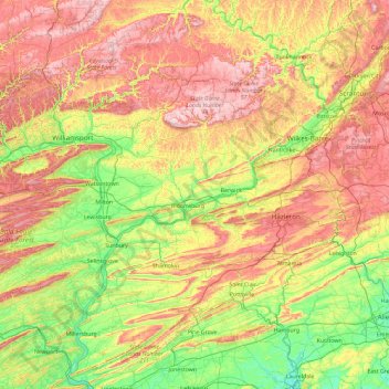
Name: Topografische Karte Columbia, Höhe, Relief.

Ort: Columbia, Columbia County, Pennsylvania, United States (40.33892 -77.11918 41.73892 -75.71918)

Durchschnittliche Höhe: 341 m

Minimale Höhe: 69 m

Maximale Höhe: 802 m

👉 Easily get elevation data in JSON, GeoTIFF and KML formats using Elevation API
Vielen Dank für die Unterstützung dieser Website ❤️
Spenden

Andere topografische Karten

Klicken Sie auf eine Karte, um ihre Topografie, ihre Höhe und ihr Relief anzuzeigen.

Raystown Lake

United States > Pennsylvania > Huntingdon County > Lincoln Township

The proposal for the new dam incorporated the ideas of bringing tourism into the area, promoting recreation, and flood control. The actual purpose stated, "The project will provide flood control, recreation, water quality and fish and wildlife enhancement" (U.S. Army Corps of Engineers, 1974). Although tourism…

Durchschnittliche Höhe: 380 m

Oley Township

United States > Pennsylvania > Berks County

Durchschnittliche Höhe: 140 m

Vielen Dank für die Unterstützung dieser Website ❤️
Spenden

Somerset

United States > Pennsylvania > Somerset County

Somerset has the ninth-highest elevation of towns in Pennsylvania, at 2,190 feet (670 m) above sea level. Somerset County is in Appalachia.

Durchschnittliche Höhe: 662 m

Madison Township

United States > Pennsylvania

Durchschnittliche Höhe: 393 m

Pennsylvania

United States > Pennsylvania

Durchschnittliche Höhe: 43 m

Vielen Dank für die Unterstützung dieser Website ❤️
Spenden

Whitehall

United States > Pennsylvania > Allegheny County

Durchschnittliche Höhe: 351 m

Richland Township

United States > Pennsylvania > Cambria County

Durchschnittliche Höhe: 589 m

Vielen Dank für die Unterstützung dieser Website ❤️
Spenden

Sugarloaf Township

United States > Pennsylvania > Columbia County

Sugarloaf Township is located in the northeast corner of Columbia County, and is bordered to the north by Sullivan County and to the east by Luzerne County. Most of the township is rolling hills, with elevations ranging from 850 to 1,300 feet (260 to 400 m), while the northern part of the township contains the…

Durchschnittliche Höhe: 393 m

Rockwood

United States > Pennsylvania > Somerset County

Durchschnittliche Höhe: 603 m

Tioga State Forest

United States > Pennsylvania > Tioga County

Durchschnittliche Höhe: 545 m

Fulton Township

United States > Pennsylvania > Lancaster County

Durchschnittliche Höhe: 113 m

Vielen Dank für die Unterstützung dieser Website ❤️
Spenden

Bellwood

United States > Pennsylvania > Blair County

Durchschnittliche Höhe: 333 m

New Florence

United States > Pennsylvania > Westmoreland County

Durchschnittliche Höhe: 346 m

Factoryville

United States > Pennsylvania > Wyoming County

Durchschnittliche Höhe: 300 m

Vielen Dank für die Unterstützung dieser Website ❤️
Spenden

Regent Square

United States > Pennsylvania > Allegheny County

Durchschnittliche Höhe: 291 m

Oakland

United States > Pennsylvania > Susquehanna County

Durchschnittliche Höhe: 356 m

East Caln Township

United States > Pennsylvania > Chester County

Durchschnittliche Höhe: 113 m

Vielen Dank für die Unterstützung dieser Website ❤️
Spenden

Paint Township

United States > Pennsylvania > Somerset County

Durchschnittliche Höhe: 603 m

Spring Mills

United States > Pennsylvania > Centre County

Durchschnittliche Höhe: 368 m

Hooversville

United States > Pennsylvania > Somerset County

Durchschnittliche Höhe: 579 m

Vielen Dank für die Unterstützung dieser Website ❤️
Spenden

Yorkana

United States > Pennsylvania > York County

Durchschnittliche Höhe: 180 m

Mont Alto

United States > Pennsylvania > Franklin County

Durchschnittliche Höhe: 281 m

Bloomfield

United States > Pennsylvania > Perry County

Durchschnittliche Höhe: 236 m

Vielen Dank für die Unterstützung dieser Website ❤️
Spenden

Tatamy

United States > Pennsylvania > Northampton County

Durchschnittliche Höhe: 114 m

Akron

United States > Pennsylvania > Lancaster County

Durchschnittliche Höhe: 126 m

New London Township

United States > Pennsylvania > Chester County

Durchschnittliche Höhe: 121 m

Zion

United States > Pennsylvania > Centre County

Durchschnittliche Höhe: 361 m

Vielen Dank für die Unterstützung dieser Website ❤️
Spenden

Brackenridge

United States > Pennsylvania > Allegheny County

Brackenridge is located at 40°36′30″N 79°44′32″W / 40.60833°N 79.74222°W / 40.60833; -79.74222. The borough's average elevation is 827 feet (252 m) above sea level. According to the U.S. Census Bureau, the borough has a total area of 0.6 square miles (1.6 km2), of which 0.5 square miles…

Durchschnittliche Höhe: 266 m

Avoca

United States > Pennsylvania > Luzerne County

Durchschnittliche Höhe: 242 m

Parkville

United States > Pennsylvania > York County > Penn Township

Durchschnittliche Höhe: 207 m

Temple

United States > Pennsylvania > Berks County > Muhlenberg Township

Temple is a census-designated place in Muhlenberg Township, Berks County, Pennsylvania, United States at an elevation of 361 feet (110 m). The community was named for a local inn called Solomon's Temple. Temple was an independent borough until it was disincorporated on January 1, 1999. The ZIP code is 19560.…

Durchschnittliche Höhe: 126 m

Vielen Dank für die Unterstützung dieser Website ❤️
Spenden

Cressona

United States > Pennsylvania > Schuylkill County

Durchschnittliche Höhe: 193 m

Vielen Dank für die Unterstützung dieser Website ❤️
Spenden

Conway

United States > Pennsylvania > Beaver County

Durchschnittliche Höhe: 255 m

Mifflintown

United States > Pennsylvania > Juniata County

Durchschnittliche Höhe: 160 m

South Waverly

United States > Pennsylvania > Bradford County

Durchschnittliche Höhe: 251 m

Georges Township

United States > Pennsylvania > Fayette County

Georges Township is in southwestern Fayette County. It surrounds the boroughs of Fairchance (near the center of the township) and Smithfield (in the southwest). Pennsylvania Route 43 (the Mon–Fayette Expressway), U.S. Route 119, and Pennsylvania Route 857 cross the township, running roughly parallel. All…

Durchschnittliche Höhe: 506 m

Vielen Dank für die Unterstützung dieser Website ❤️
Spenden

East Bangor

United States > Pennsylvania > Northampton County

Durchschnittliche Höhe: 209 m

Shiremanstown

United States > Pennsylvania > Cumberland County

Durchschnittliche Höhe: 126 m

Conyngham

United States > Pennsylvania > Luzerne County

Durchschnittliche Höhe: 327 m

Vielen Dank für die Unterstützung dieser Website ❤️
Spenden

Norwood

United States > Pennsylvania > Delaware County

Durchschnittliche Höhe: 19 m

Harrison Township

United States > Pennsylvania > Allegheny County

Durchschnittliche Höhe: 313 m

West Kittanning

United States > Pennsylvania > Armstrong County

Durchschnittliche Höhe: 300 m

Wilmerding

United States > Pennsylvania > Allegheny County

Durchschnittliche Höhe: 302 m

Vielen Dank für die Unterstützung dieser Website ❤️
Spenden

Elizabethville

United States > Pennsylvania > Dauphin County

Durchschnittliche Höhe: 242 m

Trevorton

United States > Pennsylvania > Northumberland County

Durchschnittliche Höhe: 304 m

Albion

United States > Pennsylvania > Erie County

Durchschnittliche Höhe: 279 m

Vielen Dank für die Unterstützung dieser Website ❤️
Spenden

Sayre

United States > Pennsylvania > Bradford County

Durchschnittliche Höhe: 251 m

Little Meadows

United States > Pennsylvania > Susquehanna County

Durchschnittliche Höhe: 385 m

Cadogan Township

United States > Pennsylvania > Armstrong County

Durchschnittliche Höhe: 303 m

West Hills

United States > Pennsylvania > Armstrong County

Durchschnittliche Höhe: 329 m

Vielen Dank für die Unterstützung dieser Website ❤️
Spenden

Orchard Hills

United States > Pennsylvania > Armstrong County

Durchschnittliche Höhe: 347 m

Lenape Heights

United States > Pennsylvania > Armstrong County

Durchschnittliche Höhe: 298 m

Elderton

United States > Pennsylvania > Armstrong County

Durchschnittliche Höhe: 352 m

Manorville

United States > Pennsylvania > Armstrong County

Durchschnittliche Höhe: 296 m

Vielen Dank für die Unterstützung dieser Website ❤️
Spenden

North Apollo

United States > Pennsylvania > Armstrong County

Durchschnittliche Höhe: 291 m

Rural Valley

United States > Pennsylvania > Armstrong County

Durchschnittliche Höhe: 371 m

South Bethlehem

United States > Pennsylvania > Armstrong County

Durchschnittliche Höhe: 388 m

Atwood

United States > Pennsylvania > Armstrong County

Durchschnittliche Höhe: 374 m

Vielen Dank für die Unterstützung dieser Website ❤️
Spenden

Applewold

United States > Pennsylvania > Armstrong County

Durchschnittliche Höhe: 301 m

Parker

United States > Pennsylvania > Armstrong County

Durchschnittliche Höhe: 323 m

Hanover Resevoir

United States > Pennsylvania > Adams County

Durchschnittliche Höhe: 174 m

Crescent Township

United States > Pennsylvania > Allegheny County

Durchschnittliche Höhe: 279 m

Vielen Dank für die Unterstützung dieser Website ❤️
Spenden
Vielen Dank für die Unterstützung dieser Website ❤️
Spenden

Sewickley Hills

United States > Pennsylvania > Allegheny County

Durchschnittliche Höhe: 342 m

Tarentum

United States > Pennsylvania > Allegheny County

Durchschnittliche Höhe: 278 m

Thornburg

United States > Pennsylvania > Allegheny County

Durchschnittliche Höhe: 282 m

Trafford

United States > Pennsylvania > Westmoreland County

Durchschnittliche Höhe: 294 m

Vielen Dank für die Unterstützung dieser Website ❤️
Spenden

Wall

United States > Pennsylvania > Allegheny County

Durchschnittliche Höhe: 295 m

West Elizabeth

United States > Pennsylvania > Allegheny County

Durchschnittliche Höhe: 280 m

West Homestead

United States > Pennsylvania > Allegheny County

Durchschnittliche Höhe: 283 m

Rosslyn Farms

United States > Pennsylvania > Allegheny County

Durchschnittliche Höhe: 293 m

Vielen Dank für die Unterstützung dieser Website ❤️
Spenden

Rankin

United States > Pennsylvania > Allegheny County

Durchschnittliche Höhe: 274 m

Port Vue

United States > Pennsylvania > Allegheny County

Durchschnittliche Höhe: 281 m

Pitcairn

United States > Pennsylvania > Allegheny County

Durchschnittliche Höhe: 319 m

Pennsbury Village

United States > Pennsylvania > Allegheny County

Durchschnittliche Höhe: 311 m

Vielen Dank für die Unterstützung dieser Website ❤️
Spenden

Lincoln

United States > Pennsylvania > Allegheny County

Durchschnittliche Höhe: 301 m

McDonald

United States > Pennsylvania > Washington County

Durchschnittliche Höhe: 338 m

Leetsdale

United States > Pennsylvania > Allegheny County

Durchschnittliche Höhe: 261 m

Haysville

United States > Pennsylvania > Allegheny County

Durchschnittliche Höhe: 276 m

Vielen Dank für die Unterstützung dieser Website ❤️
Spenden

Heidelberg

United States > Pennsylvania > Allegheny County

Durchschnittliche Höhe: 274 m

Glen Osborne

United States > Pennsylvania > Allegheny County

Durchschnittliche Höhe: 261 m

Glenfield

United States > Pennsylvania > Allegheny County

Durchschnittliche Höhe: 267 m

Dravosburg

United States > Pennsylvania > Allegheny County

Durchschnittliche Höhe: 290 m

Vielen Dank für die Unterstützung dieser Website ❤️
Spenden