
Spenden
Topografische Karte Sugarloaf Township
Klicken Sie auf die Karte, um die Höhe anzuzeigen.
Spenden
Sugarloaf Township
Sugarloaf Township is located in the northeast corner of Columbia County, and is bordered to the north by Sullivan County and to the east by Luzerne County. Most of the township is rolling hills, with elevations ranging from 850 to 1,300 feet (260 to 400 m), while the northern part of the township contains the southern escarpment of the Allegheny Plateau, with elevations rising to 2,341 feet (714 m) along Huckleberry Mountain in the west, to 2,250 feet (690 m) on Central Mountain to the east, and to 2,360 feet (720 m) on Red Rock Mountain in the northeastern corner.
Spenden
Über diese Karte
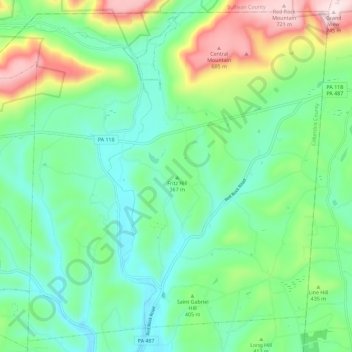
Name: Topografische Karte Sugarloaf Township, Höhe, Relief.
Durchschnittliche Höhe: 393 m
Minimale Höhe: 251 m
Maximale Höhe: 742 m
Spenden
Andere topografische Karten
Klicken Sie auf eine Karte, um ihre Topografie, ihre Höhe und ihr Relief anzuzeigen.
Briar Creek
United States > Pennsylvania > Columbia County > Briar Creek
Durchschnittliche Höhe: 183 m
Mifflin Cross Roads
United States > Pennsylvania > Columbia County > Beaver Township
Durchschnittliche Höhe: 312 m
Spenden
Byrnesville
United States > Pennsylvania > Columbia County > Conyngham Township
Durchschnittliche Höhe: 404 m
Hemlock Creek
United States > Pennsylvania > Columbia County > Buckhorn > Buckhorn
Durchschnittliche Höhe: 207 m