
Topografische Karte Banská Bystrica
Interaktive Karte
Klicken Sie auf die Karte, um die Höhe anzuzeigen.
Über diese Karte
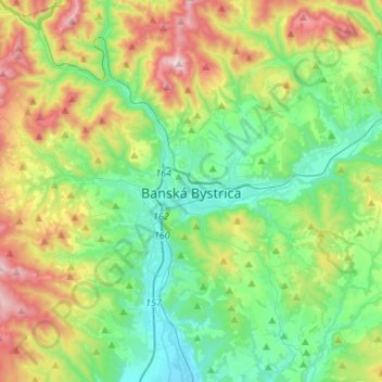
Name: Topografische Karte Banská Bystrica, Höhe, Relief.
Durchschnittliche Höhe: 566 m
Minimale Höhe: 309 m
Maximale Höhe: 1.140 m
Banská Bystrica lies at an altitude of 362 metres (1,188 ft) above sea level and covers an area of 103.37 square kilometres (39.9 sq mi). It is about halfway between Slovakia's two largest cities, 208 kilometres (129 mi) north-east from Slovakia's capital Bratislava and 217 kilometres (135 mi) west of Košice. A chain of discrete suburbs and villages connects it with Zvolen, another major town 20 kilometres (12 mi) to the south.
Andere topografische Karten
Klicken Sie auf eine Karte, um ihre Topografie, ihre Höhe und ihr Relief anzuzeigen.
Hrochoť
Slovakia > Region of Banská Bystrica > District of Banská Bystrica > Hrochoť > Hrochoť
Hrochoť, District of Banská Bystrica, Region of Banská Bystrica, Central Slovakia, 976 37, Slovakia
Durchschnittliche Höhe: 626 m
Hrochoť
Slovakia > Region of Banská Bystrica > District of Banská Bystrica
Hrochoť, District of Banská Bystrica, Region of Banská Bystrica, Central Slovakia, 976 37, Slovakia
Durchschnittliche Höhe: 597 m
Japeň
Slovakia > Region of Banská Bystrica > District of Banská Bystrica > Dolný Harmanec
Japeň, Dolný Harmanec, District of Banská Bystrica, Region of Banská Bystrica, Central Slovakia, 976 03, Slovakia
Durchschnittliche Höhe: 745 m