
Topografische Karte Hrochoť
Interaktive Karte
Klicken Sie auf die Karte, um die Höhe anzuzeigen.
Über diese Karte
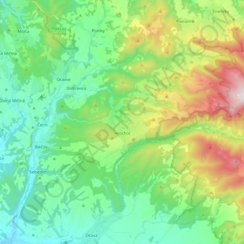
Name: Topografische Karte Hrochoť, Höhe, Relief.
Durchschnittliche Höhe: 597 m
Minimale Höhe: 324 m
Maximale Höhe: 1.263 m
Andere topografische Karten
Klicken Sie auf eine Karte, um ihre Topografie, ihre Höhe und ihr Relief anzuzeigen.
Hrochoť
Slovakia > Region of Banská Bystrica > District of Banská Bystrica > Hrochoť > Hrochoť
Hrochoť, District of Banská Bystrica, Region of Banská Bystrica, Central Slovakia, 976 37, Slovakia
Durchschnittliche Höhe: 626 m
Banská Bystrica
Slovakia > Region of Banská Bystrica > District of Banská Bystrica
Banská Bystrica, District of Banská Bystrica, Region of Banská Bystrica, Central Slovakia, Slovakia
Durchschnittliche Höhe: 566 m
Japeň
Slovakia > Region of Banská Bystrica > District of Banská Bystrica > Dolný Harmanec
Japeň, Dolný Harmanec, District of Banská Bystrica, Region of Banská Bystrica, Central Slovakia, 976 03, Slovakia
Durchschnittliche Höhe: 745 m