
Topografische Karte Aunay-sur-Odon
Interaktive Karte
Klicken Sie auf die Karte, um die Höhe anzuzeigen.
Über diese Karte
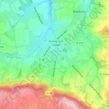
Name: Topografische Karte Aunay-sur-Odon, Höhe, Relief.
Durchschnittliche Höhe: 172 m
Minimale Höhe: 99 m
Maximale Höhe: 310 m
Andere topografische Karten
Klicken Sie auf eine Karte, um ihre Topografie, ihre Höhe und ihr Relief anzuzeigen.
Le Plessis-Grimoult
France > Normandie > Calvados > Les Monts d'Aunay
Le Plessis-Grimoult, Les Monts d'Aunay, Vire, Calvados, Normandie, France métropolitaine, 14770, France
Durchschnittliche Höhe: 258 m
Les Monts d'Aunay
France > Normandie > Calvados > Les Monts d'Aunay > Les Monts d'Aunay
Les Monts d'Aunay, Vire, Calvados, Normandie, France métropolitaine, 14260, France
Durchschnittliche Höhe: 151 m
La Grellerie
France > Normandie > Calvados > Les Monts d'Aunay > Aunay-sur-Odon
La Grellerie, Aunay-sur-Odon, Les Monts d'Aunay, Vire, Calvados, Normandie, France métropolitaine, 14260, France
Durchschnittliche Höhe: 177 m
Ondefontaine
France > Normandie > Calvados > Les Monts d'Aunay
Ondefontaine, Les Monts d'Aunay, Vire, Calvados, Normandie, France métropolitaine, 14260, France
Durchschnittliche Höhe: 238 m
Mont Pinçon
France > Normandie > Calvados > Les Monts d'Aunay
Mont Pinçon, Les Monts d'Aunay, Vire, Calvados, Normandie, France métropolitaine, 14770, France
Durchschnittliche Höhe: 281 m
Campandré-Valcongrain
France > Normandie > Calvados > Les Monts d'Aunay
Campandré-Valcongrain, Les Monts d'Aunay, Vire, Calvados, Normandie, France métropolitaine, 14260, France
Durchschnittliche Höhe: 238 m