
Vielen Dank für die Unterstützung dieser Website ❤️
Spenden
Spenden
Topografische Karte Le Plessis-Grimoult
Klicken Sie auf die Karte, um die Höhe anzuzeigen.
Vielen Dank für die Unterstützung dieser Website ❤️
Spenden
Spenden
Über diese Karte
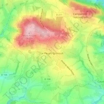
Name: Topografische Karte Le Plessis-Grimoult, Höhe, Relief.
Durchschnittliche Höhe: 258 m
Minimale Höhe: 179 m
Maximale Höhe: 356 m
Vielen Dank für die Unterstützung dieser Website ❤️
Spenden
Spenden
Andere topografische Karten
Klicken Sie auf eine Karte, um ihre Topografie, ihre Höhe und ihr Relief anzuzeigen.
Les Monts d'Aunay
France > Normandie > Calvados > Les Monts d'Aunay > Les Monts d'Aunay
Durchschnittliche Höhe: 151 m
La Grellerie
France > Normandie > Calvados > Les Monts d'Aunay > Aunay-sur-Odon
Durchschnittliche Höhe: 177 m
Vielen Dank für die Unterstützung dieser Website ❤️
Spenden
Spenden