Geolokalisieren
👉 Easily get elevation data in JSON, GeoTIFF and KML formats using Elevation API
Vielen Dank für die Unterstützung dieser Website ❤️
Spenden

Topografische Karte River Thames

Klicken Sie auf die Karte, um die Höhe anzuzeigen.

👉 Easily get elevation data in JSON, GeoTIFF and KML formats using Elevation API
Vielen Dank für die Unterstützung dieser Website ❤️
Spenden

Über diese Karte

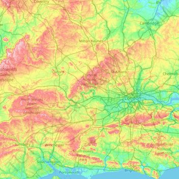
Name: Topografische Karte River Thames, Höhe, Relief.

Ort: River Thames, England, United Kingdom (51.37841 -2.02968 51.79032 0.67789)

Durchschnittliche Höhe: 84 m

Minimale Höhe: -3 m

Maximale Höhe: 327 m

👉 Easily get elevation data in JSON, GeoTIFF and KML formats using Elevation API
Vielen Dank für die Unterstützung dieser Website ❤️
Spenden

Andere topografische Karten

Klicken Sie auf eine Karte, um ihre Topografie, ihre Höhe und ihr Relief anzuzeigen.

London

United Kingdom > England > London

Durchschnittliche Höhe: 42 m

Huddersfield

United Kingdom > England > Kirklees

Durchschnittliche Höhe: 145 m

Leicester

United Kingdom > England > City of Leicester

Durchschnittliche Höhe: 109 m

Cambridge

United Kingdom > England > Cambridge

The city, like most of the UK, has a maritime climate highly influenced by the Gulf Stream. Located in the driest region of Britain, Cambridge's rainfall averages around 570 mm (22.44 in) per year, around half the national average, with some years occasionally falling into the semi-arid (under 500 mm (19.69…

Durchschnittliche Höhe: 18 m

Vielen Dank für die Unterstützung dieser Website ❤️
Spenden

Poole Bay

United Kingdom > England

Durchschnittliche Höhe: 0 m

The Wells

United Kingdom > England > Surrey > Epsom and Ewell

Durchschnittliche Höhe: 63 m

Brierley Hill

United Kingdom > England

Durchschnittliche Höhe: 122 m

Leeds

United Kingdom > England

Lying in the eastern foothills of the Pennines, there is a significant variation in elevation within the city's built-up area. The district ranges from 1,115 feet (340 m) in the far west on the slopes of Ilkley Moor to about 33 feet (10 m) where the rivers Aire and Wharfe cross the eastern boundary. Land rises…

Durchschnittliche Höhe: 94 m

Vielen Dank für die Unterstützung dieser Website ❤️
Spenden

Derby

United Kingdom > England > Derbyshire

Durchschnittliche Höhe: 97 m

Langton Green

United Kingdom > England > Kent > Tunbridge Wells

Durchschnittliche Höhe: 94 m

Ilkley Moor

United Kingdom > England > Bradford

Durchschnittliche Höhe: 259 m

Vielen Dank für die Unterstützung dieser Website ❤️
Spenden

Folkestone

United Kingdom > England > Folkestone

Durchschnittliche Höhe: 46 m

Honiton

United Kingdom > England > Honiton

Durchschnittliche Höhe: 158 m

Whitley Bay

United Kingdom > England > Tyne and Wear > North Tyneside

Durchschnittliche Höhe: 21 m

Portsmouth

United Kingdom > England > Hampshire > Portsmouth

By road, Portsmouth lies 73.5 miles (118.3 km) from Central London, 49.5 miles (79.7 km) west of Brighton, and 22.3 miles (35.9 km) east of Southampton. Portsmouth is situated primarily on Portsea Island and is the United Kingdom's only island city, although parts of it have expanded onto the mainland. Gosport…

Durchschnittliche Höhe: 28 m

Vielen Dank für die Unterstützung dieser Website ❤️
Spenden

Clifton Down

United Kingdom > England > City of Bristol > Bristol

Durchschnittliche Höhe: 73 m

Crystal Palace Park

United Kingdom > England > London

Durchschnittliche Höhe: 73 m

Crowborough

United Kingdom > England > Wealden > Crowborough

In the late 19th century Crowborough was promoted as a health resort based on its high elevation, the rolling hills and surrounding forest. Estate Agents even called it "Scotland in Sussex". The town's golf course opened in 1895, followed by a fire station and hospital in 1900.

Durchschnittliche Höhe: 125 m

Redcar

United Kingdom > England > North Yorkshire

Durchschnittliche Höhe: 8 m

Vielen Dank für die Unterstützung dieser Website ❤️
Spenden

Romford

United Kingdom > England > Greater London

The town centre is about 50 feet (15 m) above sea level on a gravel terrace rising from the River Thames. The north of the town has developed on London Clay and is situated as much as 150 ft (46 m) above sea level. A continuous gentle rise in the eastern suburbs towards Gidea Park and Harold Wood peaks around…

Durchschnittliche Höhe: 29 m

Basingstoke

United Kingdom > England > Hampshire > Basingstoke and Deane

Situated in a valley through the Hampshire Downs at an average elevation of 88 metres (289 ft) Basingstoke is a major interchange between Reading, Newbury, Andover, Winchester, and Alton, and lies on the natural trade route between the southwest of England and London. The area had been something of an…

Durchschnittliche Höhe: 109 m

Hebden Bridge

United Kingdom > England > Calderdale

Durchschnittliche Höhe: 277 m

York

United Kingdom > England > York

Durchschnittliche Höhe: 21 m

Vielen Dank für die Unterstützung dieser Website ❤️
Spenden

Brighton

United Kingdom > England > Brighton and Hove

Durchschnittliche Höhe: 64 m

Chidden

United Kingdom > England > Hampshire > Winchester

Durchschnittliche Höhe: 124 m

Holland Park

United Kingdom > England > Greater London

Durchschnittliche Höhe: 17 m

The Mount

United Kingdom > England > Devon > South Hams > Totnes

Durchschnittliche Höhe: 70 m

Vielen Dank für die Unterstützung dieser Website ❤️
Spenden

Cowbit

United Kingdom > England > Lincolnshire > South Holland

Durchschnittliche Höhe: 3 m

Bellingdon

United Kingdom > England > Buckinghamshire

Durchschnittliche Höhe: 164 m

Cheadle

United Kingdom > England

Durchschnittliche Höhe: 59 m

Vielen Dank für die Unterstützung dieser Website ❤️
Spenden

Yeovilton

United Kingdom > England > Somerset

Durchschnittliche Höhe: 20 m

Scarborough

United Kingdom > England > North Yorkshire

The climate is temperate with mild summers and cool, windy, winters. The hottest months of the year are July and August, with temperatures reaching an average high of 17 °C and falling to 11 °C at night. The average daytime temperatures in January are 4 °C, falling to 1 °C at night. The station's elevation…

Durchschnittliche Höhe: 39 m

Porth

United Kingdom > England > Cornwall > Newquay

Durchschnittliche Höhe: 28 m

Vielen Dank für die Unterstützung dieser Website ❤️
Spenden

Pound Hill

United Kingdom > England > West Sussex > Crawley

Durchschnittliche Höhe: 80 m

Land's End

United Kingdom > England > Cornwall > Sennen Cove

Durchschnittliche Höhe: 24 m

Dinnington

United Kingdom > England

Durchschnittliche Höhe: 91 m

Vielen Dank für die Unterstützung dieser Website ❤️
Spenden

Leatherhead

United Kingdom > England > Surrey > Mole Valley

Durchschnittliche Höhe: 81 m

East Finchley

United Kingdom > England > London > East Finchley

Durchschnittliche Höhe: 67 m

Catford

United Kingdom > England > Greater London

Durchschnittliche Höhe: 38 m

Vielen Dank für die Unterstützung dieser Website ❤️
Spenden

Lechlade

United Kingdom > England > Gloucestershire > Cotswold District

Durchschnittliche Höhe: 81 m

Hampstead Heath

United Kingdom > England > Greater London

Durchschnittliche Höhe: 94 m

River Mersey

United Kingdom > England > Stockport

Durchschnittliche Höhe: 68 m

Caterham on the Hill

United Kingdom > England > Surrey

Durchschnittliche Höhe: 172 m

Vielen Dank für die Unterstützung dieser Website ❤️
Spenden

Isles of Scilly

United Kingdom > England

Durchschnittliche Höhe: 2 m

Walthamstow

United Kingdom > England > Greater London

Durchschnittliche Höhe: 21 m

Richmond Park

United Kingdom > England > Greater London

Durchschnittliche Höhe: 26 m

Bexleyheath

United Kingdom > England

Durchschnittliche Höhe: 29 m

Vielen Dank für die Unterstützung dieser Website ❤️
Spenden

Bishop Auckland

United Kingdom > England > Bishop Auckland

Durchschnittliche Höhe: 124 m

Worksop

United Kingdom > England > Nottinghamshire > Bassetlaw

Durchschnittliche Höhe: 56 m

Biggin Hill

United Kingdom > England > London

Durchschnittliche Höhe: 171 m

Swanage

United Kingdom > England > Swanage

Durchschnittliche Höhe: 28 m

Vielen Dank für die Unterstützung dieser Website ❤️
Spenden

Louth

United Kingdom > England > Louth

Durchschnittliche Höhe: 50 m

Accrington

United Kingdom > England > Lancashire > Hyndburn

Geographical coordinates: 53° 46' 0" North, 2° 21' 0" West. Height above sea level: there is a spot height outside the Market Hall which is 133.5 metres (438 ft) the benchmark on the side of the neighbouring Town Hall is 441.10 feet (134.45 m). The highest height in the town is 320 metres (1,050 ft) which is…

Durchschnittliche Höhe: 199 m

Banbury

United Kingdom > England > Cherwell > Banbury

Durchschnittliche Höhe: 119 m

Oswestry

United Kingdom > England > Shropshire

Durchschnittliche Höhe: 158 m

Vielen Dank für die Unterstützung dieser Website ❤️
Spenden

Bridgwater

United Kingdom > England > Bridgwater

Durchschnittliche Höhe: 17 m

Camborne

United Kingdom > England > Camborne

Durchschnittliche Höhe: 101 m

Chesham

United Kingdom > England > Buckinghamshire

Durchschnittliche Höhe: 147 m

Tring

United Kingdom > England > Tring

Durchschnittliche Höhe: 157 m

Vielen Dank für die Unterstützung dieser Website ❤️
Spenden

Ambleside

United Kingdom > England > Westmorland and Furness

Durchschnittliche Höhe: 212 m

Cirencester

United Kingdom > England > Cirencester

Durchschnittliche Höhe: 130 m

Nuneaton

United Kingdom > England > Warwickshire > Nuneaton and Bedworth

Durchschnittliche Höhe: 102 m

Orpington

United Kingdom > England > Greater London

Durchschnittliche Höhe: 89 m

Vielen Dank für die Unterstützung dieser Website ❤️
Spenden

Teignmouth

United Kingdom > England > Teignmouth

Durchschnittliche Höhe: 52 m

Teignmouth Beach

United Kingdom > England > Devon > Teignbridge > Teignmouth > Shaldon

Durchschnittliche Höhe: 24 m

Salisbury

United Kingdom > England > Salisbury

Bishop of Salisbury Hubert Walter was instrumental in the negotiations with Saladin during the Third Crusade, but he spent little time in his diocese prior to his elevation to archbishop of Canterbury. The brothers Herbert and Richard Poore succeeded him and began planning the relocation of the cathedral into…

Durchschnittliche Höhe: 96 m

Taunton

United Kingdom > England > Somerset

Durchschnittliche Höhe: 39 m

Vielen Dank für die Unterstützung dieser Website ❤️
Spenden

Kingston upon Thames

United Kingdom > England > Greater London

Durchschnittliche Höhe: 19 m

Stanley

United Kingdom > England > Stanley

Durchschnittliche Höhe: 170 m

Bedford

United Kingdom > England > Bedford

As with the rest of the United Kingdom, Bedford has a maritime climate, with a limited range of temperatures, and generally even rainfall throughout the year. The nearest Met Office weather station to Bedford is Bedford (Thurleigh) airport, about 6.5 miles (10.5 km) north of Bedford town centre at an elevation…

Durchschnittliche Höhe: 37 m

Reading

United Kingdom > England > Reading

Mary Russell Mitford lived in Reading for a number of years and then spent the rest of her life just outside the town at Three Mile Cross and Swallowfield. The fictional Belford Regis of her eponymous novel, first published in 1835, is largely based on Reading. Described with topographical accuracy, it is…

Durchschnittliche Höhe: 56 m

Vielen Dank für die Unterstützung dieser Website ❤️
Spenden

Torquay

United Kingdom > England > Torbay

Durchschnittliche Höhe: 31 m

Twyford Down

United Kingdom > England > Hampshire > Winchester

Durchschnittliche Höhe: 59 m

Heswall

United Kingdom > England

Durchschnittliche Höhe: 36 m

Moreton

United Kingdom > England

Durchschnittliche Höhe: 16 m

Vielen Dank für die Unterstützung dieser Website ❤️
Spenden

Bideford Bay

United Kingdom > England

Durchschnittliche Höhe: 0 m

Mount's Bay

United Kingdom > England

Durchschnittliche Höhe: 0 m

Falmouth Bay

United Kingdom > England

Durchschnittliche Höhe: 0 m

Lyme Bay

United Kingdom > England

Durchschnittliche Höhe: 0 m

Vielen Dank für die Unterstützung dieser Website ❤️
Spenden

Liverpool Bay

United Kingdom > England

Durchschnittliche Höhe: 0 m

Gayton

United Kingdom > England

Durchschnittliche Höhe: 41 m

Keston

United Kingdom > England

Durchschnittliche Höhe: 104 m

Harefield

United Kingdom > England

Durchschnittliche Höhe: 66 m

Vielen Dank für die Unterstützung dieser Website ❤️
Spenden

Eastham Village

United Kingdom > England

Durchschnittliche Höhe: 24 m

Greasby

United Kingdom > England

Durchschnittliche Höhe: 32 m

Middleton

United Kingdom > England

Durchschnittliche Höhe: 113 m

Vielen Dank für die Unterstützung dieser Website ❤️
Spenden

Atherton

United Kingdom > England

There were several ministers of note of Chowbent Chapel including James Wood, the "General" (1672–1759), who distinguished himself at the Battle of Preston in 1715. Thomas Walker Horsfield (1792–1837) was a historian and topographer. Joseph Nightingale (1775–1824), born in Chowbent, was a prolific…

Durchschnittliche Höhe: 69 m

Tottenham

United Kingdom > England

Tottenham's elevation is approximately 33 ft (10 m) above sea level.

Durchschnittliche Höhe: 25 m

Old Town

United Kingdom > England

Durchschnittliche Höhe: 7 m

Raby Mere

United Kingdom > England

Durchschnittliche Höhe: 33 m

Vielen Dank für die Unterstützung dieser Website ❤️
Spenden

Acton

United Kingdom > England

Durchschnittliche Höhe: 23 m

Noak Hill

United Kingdom > England

Durchschnittliche Höhe: 67 m

Wath upon Dearne

United Kingdom > England

Durchschnittliche Höhe: 51 m

Milnrow

United Kingdom > England

Durchschnittliche Höhe: 210 m

Vielen Dank für die Unterstützung dieser Website ❤️
Spenden