
Topografische Karte Bullhead City
Interaktive Karte
Klicken Sie auf die Karte, um die Höhe anzuzeigen.
Über diese Karte
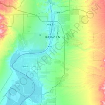
Name: Topografische Karte Bullhead City, Höhe, Relief.
Durchschnittliche Höhe: 322 m
Minimale Höhe: 144 m
Maximale Höhe: 774 m
Hardyville Pioneer Cemetery, a small cemetery, now a historic landmark, is the most significant existing remnant of Hardyville at 35°7′16″N 114°35′17″W / 35.12111°N 114.58806°W / 35.12111; -114.58806. An unofficial historical marker for the town is in the parking lot across Highway 95 from the cemetery at 35°7′16″N 114°35′17″W / 35.12111°N 114.58806°W / 35.12111; -114.58806. The Hardyville Mill ruins appeared on a USGS Topographic map, at 35°7′14″N 114°34′47″W / 35.12056°N 114.57972°W / 35.12056; -114.57972.