
Topografische Karte Cathedral Bluffs
Interaktive Karte
Klicken Sie auf die Karte, um die Höhe anzuzeigen.
Über diese Karte
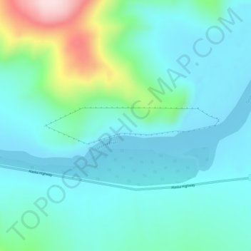
Name: Topografische Karte Cathedral Bluffs, Höhe, Relief.
Durchschnittliche Höhe: 514 m
Minimale Höhe: 449 m
Maximale Höhe: 781 m
Andere topografische Karten
Klicken Sie auf eine Karte, um ihre Topografie, ihre Höhe und ihr Relief anzuzeigen.
Fulton Falls
United States of America > Alaska
Fulton Falls, Kodiak Island, Alaska, United States of America
Durchschnittliche Höhe: 326 m
Ketchikan
United States of America > Alaska > Ketchikan
Ketchikan, Ketchikan Gateway, Alaska, 99901, United States of America
Durchschnittliche Höhe: 150 m
Kilarney Creek
United States of America > Alaska
Kilarney Creek, Unorganized Borough, Alaska, United States of America
Durchschnittliche Höhe: 329 m
Maid Lake
United States of America > Alaska
Maid Lake, Iditarod National Historic Trail, Matanuska-Susitna, Alaska, United States of America
Durchschnittliche Höhe: 8 m
Sheep River
United States of America > Alaska
Sheep River, Matanuska-Susitna, Alaska, United States of America
Durchschnittliche Höhe: 256 m
Kenai
United States of America > Alaska > Kenai
Kenai, Kenai Peninsula, Alaska, United States of America
Durchschnittliche Höhe: 16 m
Nanwalek
United States of America > Alaska > Nanwalek
Nanwalek, Kenai Peninsula, Alaska, United States of America
Durchschnittliche Höhe: 74 m
Adak Island
United States of America > Alaska
Adak Island, Unorganized Borough, Alaska, 99546, United States of America
Durchschnittliche Höhe: 68 m
Harding Lake
United States of America > Alaska > Harding Lake
Harding Lake, Fairbanks North Star, Alaska, United States of America
Durchschnittliche Höhe: 232 m