
Topografische Karte Ketchikan
Interaktive Karte
Klicken Sie auf die Karte, um die Höhe anzuzeigen.
Über diese Karte
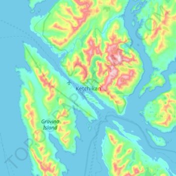
Name: Topografische Karte Ketchikan, Höhe, Relief.
Durchschnittliche Höhe: 150 m
Minimale Höhe: -13 m
Maximale Höhe: 1.027 m
Due to its steep and forested terrain, Ketchikan is long and narrow with much of the built-up area being located along, or no more than a few city blocks from, the waterfront. Elevations of inhabited areas range from just above sea level to about 300 feet (91 m). Deer Mountain, a 3,001-foot (915 m) peak, rises immediately east of the city's downtown area.