
Spenden
Topografische Karte State College
Klicken Sie auf die Karte, um die Höhe anzuzeigen.
Spenden
State College
Weather in State College is strongly influenced by the mountain and valley topology of the area. The surrounding mountains cause significantly lower temperatures in the winter, and make summer heat waves much rarer than in the rest of the state. Precipitation is about 20% lower than areas at comparable elevations, again due to the surrounding mountains. Snowfall typically occurs between October and April, but has happened as late as June.
Spenden
Über diese Karte
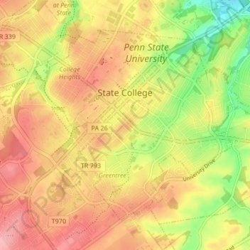
Name: Topografische Karte State College, Höhe, Relief.
Ort: State College, Centre County, Pennsylvania, United States (40.76837 -77.88617 40.80723 -77.81900)
Durchschnittliche Höhe: 351 m
Minimale Höhe: 286 m
Maximale Höhe: 398 m
Spenden
Andere topografische Karten
Klicken Sie auf eine Karte, um ihre Topografie, ihre Höhe und ihr Relief anzuzeigen.
Krumrine
United States > Pennsylvania > Centre County > Ferguson Township
Durchschnittliche Höhe: 360 m
Pleasant View
United States > Pennsylvania > Centre County > Spring Township
Durchschnittliche Höhe: 296 m
Green Grove
United States > Pennsylvania > Centre County > Gregg Township
Durchschnittliche Höhe: 428 m
Dalevue Park
United States > Pennsylvania > Centre County > State College > Dalevue
Durchschnittliche Höhe: 331 m
Spenden
Krumrine
United States > Pennsylvania > Centre County > Ferguson Township
Durchschnittliche Höhe: 360 m
Loch Lomond Junction
United States > Pennsylvania > Centre County > Rush Township
Durchschnittliche Höhe: 460 m