
Spenden
Topografische Karte Poe Valley State Park
Klicken Sie auf die Karte, um die Höhe anzuzeigen.
Spenden
Über diese Karte
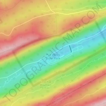
Name: Topografische Karte Poe Valley State Park, Höhe, Relief.
Durchschnittliche Höhe: 501 m
Minimale Höhe: 383 m
Maximale Höhe: 611 m
Spenden
Andere topografische Karten
Klicken Sie auf eine Karte, um ihre Topografie, ihre Höhe und ihr Relief anzuzeigen.
State College
United States > Pennsylvania > Centre County
State College is situated at an elevation of approximately 1,200 feet (370 m) above sea level. According to the U.S. Census Bureau, the borough has a total area of 4.5 square miles (12 km2), all of it land. It is surrounded by large tracts of farmland, and an expanse of Appalachian Mountain ranges and forests.…
Durchschnittliche Höhe: 351 m
Spenden
Krumrine
United States > Pennsylvania > Centre County > Ferguson Township
Durchschnittliche Höhe: 360 m
Pleasant View
United States > Pennsylvania > Centre County > Spring Township
Durchschnittliche Höhe: 296 m
Spenden
Black Moshannon State Park
United States > Pennsylvania > Centre County > Rush Township
Black Moshannon State Park is open year-round for recreation and has an extensive network of trails which allow hiking, biking, and viewing the bog habitat at the Black Moshannon State Natural Area. The park is in a Pennsylvania Important Bird Area, where bird watchers have recorded 175 species. It is also…
Durchschnittliche Höhe: 602 m
Ramblewood
United States > Pennsylvania > Centre County > Ferguson Township > The Meadows
Durchschnittliche Höhe: 396 m
Park Forest Village
United States > Pennsylvania > Centre County > Ferguson Township
Durchschnittliche Höhe: 387 m
Spenden
Pleasant Gap
United States > Pennsylvania > Centre County > Spring Township > Pleasant Gap
Durchschnittliche Höhe: 327 m
Spenden
Houserville
United States > Pennsylvania > Centre County > College Township > Houserville
Durchschnittliche Höhe: 315 m
State College
United States > Pennsylvania > Centre County
State College is situated at an elevation of approximately 1,200 feet (370 m) above sea level. According to the U.S. Census Bureau, the borough has a total area of 4.5 square miles (12 km2), all of it land. It is surrounded by large tracts of farmland, and an expanse of Appalachian Mountain ranges and forests.…
Durchschnittliche Höhe: 351 m
Woodward
United States > Pennsylvania > Centre County > Haines Township > Woodward
Durchschnittliche Höhe: 447 m
Boalsburg
United States > Pennsylvania > Centre County > Harris Township > Boalsburg
Durchschnittliche Höhe: 426 m
Spenden
Green Grove
United States > Pennsylvania > Centre County > Gregg Township
Durchschnittliche Höhe: 428 m
Spenden
Woodward
United States > Pennsylvania > Centre County > Haines Township > Woodward
Durchschnittliche Höhe: 447 m
Spenden
State College
United States > Pennsylvania > Centre County
Weather in State College is strongly influenced by the mountain and valley topology of the area. The surrounding mountains cause significantly lower temperatures in the winter, and make summer heat waves much rarer than in the rest of the state. Precipitation is about 20% lower than areas at comparable…
Durchschnittliche Höhe: 351 m
Coburn
United States > Pennsylvania > Centre County > Penn Township > Coburn
Durchschnittliche Höhe: 364 m
Spenden
Krumrine
United States > Pennsylvania > Centre County > Ferguson Township
Durchschnittliche Höhe: 360 m
Loch Lomond Junction
United States > Pennsylvania > Centre County > Rush Township
Durchschnittliche Höhe: 460 m
Spenden
State College
United States > Pennsylvania > Centre County
Weather in State College is strongly influenced by the mountain and valley topology of the area. The surrounding mountains cause significantly lower temperatures in the winter, and make summer heat waves much rarer than in the rest of the state. Precipitation is about 20% lower than areas at comparable…
Durchschnittliche Höhe: 351 m
Bald Eagle State Park
United States > Pennsylvania > Centre County > Howard Township
Foster Joseph Sayers Reservoir is a 1,730-acre (700 ha) reservoir that was built in 1971 by the U.S. Army Corps of Engineers as part of a flood control project on the Susquehanna River basin. The lake was created by damming Bald Eagle Creek. It stretches upstream for 8 miles (12.87 km) and has 23 miles (37.01…
Durchschnittliche Höhe: 290 m