
Spenden
Topografische Karte Parrs Mill
Klicken Sie auf die Karte, um die Höhe anzuzeigen.
Spenden
Über diese Karte
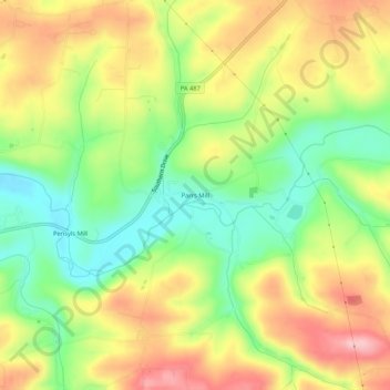
Name: Topografische Karte Parrs Mill, Höhe, Relief.
Ort: Parrs Mill, Columbia County, Pennsylvania, United States (40.88703 -76.49217 40.92703 -76.45217)
Durchschnittliche Höhe: 255 m
Minimale Höhe: 173 m
Maximale Höhe: 345 m
Spenden
Andere topografische Karten
Klicken Sie auf eine Karte, um ihre Topografie, ihre Höhe und ihr Relief anzuzeigen.
Briar Creek
United States > Pennsylvania > Columbia County > Briar Creek
Durchschnittliche Höhe: 183 m
Spenden
Spenden
Sugarloaf Township
United States > Pennsylvania > Columbia County
Sugarloaf Township is located in the northeast corner of Columbia County, and is bordered to the north by Sullivan County and to the east by Luzerne County. Most of the township is rolling hills, with elevations ranging from 850 to 1,300 feet (260 to 400 m), while the northern part of the township contains the…
Durchschnittliche Höhe: 393 m
Buckhorn
United States > Pennsylvania > Columbia County > Buckhorn > Buckhorn
Durchschnittliche Höhe: 197 m
Spenden
Iola
United States > Pennsylvania > Columbia County > Greenwood Township > Iola
Durchschnittliche Höhe: 257 m
Spenden
Lightstreet
United States > Pennsylvania > Columbia County > Scott Township > Lightstreet
Durchschnittliche Höhe: 210 m
Spenden
Locustdale
United States > Pennsylvania > Columbia County > Conyngham Township
Durchschnittliche Höhe: 386 m
Numidia
United States > Pennsylvania > Columbia County > Locust Township > Numidia
Durchschnittliche Höhe: 298 m
Spenden
Wilburton Number One
United States > Pennsylvania > Columbia County > Conyngham Township
Wilburton Number One is on the top of a mountain, at an elevation of 1,540 feet (470 m). Wilburton Number One's land is a mixture of forest and residential.
Durchschnittliche Höhe: 439 m
Spenden
Hemlock Creek
United States > Pennsylvania > Columbia County > Buckhorn > Buckhorn
Durchschnittliche Höhe: 207 m