Geolokalisieren
👉 Easily get elevation data in JSON, GeoTIFF and KML formats using Elevation API
Vielen Dank für die Unterstützung dieser Website ❤️
Spenden

Topografische Karte County Donegal

Klicken Sie auf die Karte, um die Höhe anzuzeigen.

👉 Easily get elevation data in JSON, GeoTIFF and KML formats using Elevation API
Vielen Dank für die Unterstützung dieser Website ❤️
Spenden

County Donegal

The majority of Donegal has a temperate oceanic climate (Köppen climate classification: Cfb), with upland areas in the Derryveagh and Blue Stack ranges classified as oceanic subpolar (Köppen climate classification: Cfc). The county's climate is heavily influenced by the North Atlantic Current. Due to the topography of western Donegal, it receives orographic rainfall, where the air is forced to rise on contact with its mountainous coastline and subsequently cools and condenses, forming clouds. The mountains of Donegal are among the cloudiest places in Ireland, and northern Donegal is the windiest. Irish monthly record wind speeds for March, June, July, September, November and December have all been set at Malin Head. The highest wind speed ever recorded in Donegal was 181 km/h (112 mph) on 16 September 1961, during Hurricane Debbie.

Wikipedia (CC-BY-SA 3.0)

👉 Easily get elevation data in JSON, GeoTIFF and KML formats using Elevation API
Vielen Dank für die Unterstützung dieser Website ❤️
Spenden

Über diese Karte

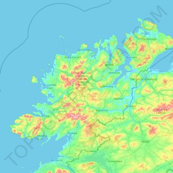
Name: Topografische Karte County Donegal, Höhe, Relief.

Ort: County Donegal, Ulster, Ireland (54.45905 -8.83471 55.45100 -6.92224)

Durchschnittliche Höhe: 73 m

Minimale Höhe: -4 m

Maximale Höhe: 700 m

👉 Easily get elevation data in JSON, GeoTIFF and KML formats using Elevation API
Vielen Dank für die Unterstützung dieser Website ❤️
Spenden

Andere topografische Karten

Klicken Sie auf eine Karte, um ihre Topografie, ihre Höhe und ihr Relief anzuzeigen.

Cork

Ireland > County Cork > Cork

Durchschnittliche Höhe: 94 m

Letterkenny

Ireland > County Donegal > Letterkenny

Durchschnittliche Höhe: 93 m

Ennis

Ireland > County Clare > Ennis

Durchschnittliche Höhe: 20 m

Kilternan

Ireland > County Dublin

Durchschnittliche Höhe: 173 m

Vielen Dank für die Unterstützung dieser Website ❤️
Spenden

Galway City

Ireland > Galway City

Durchschnittliche Höhe: 26 m

River Shannon

Ireland

Durchschnittliche Höhe: 39 m

Dublin

Ireland > Dublin

Durchschnittliche Höhe: 19 m

Benbulbin

Ireland > County Sligo

Durchschnittliche Höhe: 257 m

Vielen Dank für die Unterstützung dieser Website ❤️
Spenden

Cromane

Ireland

Durchschnittliche Höhe: 3 m

Maghera Strand

Ireland

Durchschnittliche Höhe: 37 m

Knockdrin

Ireland

Durchschnittliche Höhe: 96 m

Ballycurry

Ireland

Durchschnittliche Höhe: 178 m

Vielen Dank für die Unterstützung dieser Website ❤️
Spenden

Ballyedmond

Ireland

Durchschnittliche Höhe: 73 m

Furry Glen

Ireland

Durchschnittliche Höhe: 44 m

Trout Lake

Ireland

Durchschnittliche Höhe: 81 m

Tory Hill

Ireland

Durchschnittliche Höhe: 131 m

Vielen Dank für die Unterstützung dieser Website ❤️
Spenden

Dowth

Ireland

Durchschnittliche Höhe: 32 m

Great Skellig

Ireland

Durchschnittliche Höhe: 1 m

Spinans Hill

Ireland

Durchschnittliche Höhe: 244 m

Gaulstown Castle

Ireland

Durchschnittliche Höhe: 181 m

Vielen Dank für die Unterstützung dieser Website ❤️
Spenden

Skeaghvasteen

Ireland

Durchschnittliche Höhe: 97 m

Tibberaghny Castle

Ireland

Durchschnittliche Höhe: 18 m

Myles Big Stone

Ireland

Durchschnittliche Höhe: 89 m

Kilkee Cliffs

Ireland

Durchschnittliche Höhe: 19 m

Vielen Dank für die Unterstützung dieser Website ❤️
Spenden

Dunlicky Point

Ireland

Durchschnittliche Höhe: 18 m

Doulus Head

Ireland

Durchschnittliche Höhe: 16 m

Bolus Head

Ireland

Durchschnittliche Höhe: 28 m

Galley Head

Ireland

Durchschnittliche Höhe: 3 m

Vielen Dank für die Unterstützung dieser Website ❤️
Spenden

Downeen Point

Ireland

Durchschnittliche Höhe: 11 m

Frower Point

Ireland

Durchschnittliche Höhe: 20 m

Knockadoon Head

Ireland

Durchschnittliche Höhe: 6 m

Mine Head

Ireland

Durchschnittliche Höhe: 22 m

Vielen Dank für die Unterstützung dieser Website ❤️
Spenden

Glendoo Mountain

Ireland

Durchschnittliche Höhe: 480 m

Crohy Head Sea Arch

Ireland

Durchschnittliche Höhe: 28 m

Dawros Bay

Ireland

Durchschnittliche Höhe: 6 m

Portacloy Bay

Ireland

Durchschnittliche Höhe: 57 m

Vielen Dank für die Unterstützung dieser Website ❤️
Spenden

Mace Head

Ireland

Durchschnittliche Höhe: 3 m

Doonbeg Head

Ireland

Durchschnittliche Höhe: 32 m

Lambs Head Bay

Ireland

Durchschnittliche Höhe: 14 m

Clifden Bay

Ireland

Durchschnittliche Höhe: 41 m

Vielen Dank für die Unterstützung dieser Website ❤️
Spenden

Galway Bay

Ireland

Durchschnittliche Höhe: 0 m

Dollymount

Ireland

Durchschnittliche Höhe: 6 m

Clondrohid

Ireland > County Cork

Durchschnittliche Höhe: 151 m

Dundalk

Ireland > County Louth > Dundalk

Durchschnittliche Höhe: 16 m

Vielen Dank für die Unterstützung dieser Website ❤️
Spenden

Drogheda

Ireland > County Louth > Drogheda

Durchschnittliche Höhe: 38 m

Enniscorthy

Ireland > County Wexford > Enniscorthy

Durchschnittliche Höhe: 44 m

Swords

Ireland > County Dublin > Swords

The medieval town developed in a linear pattern along Main Street, in a roughly north-south direction. Swords has one of the best examples of this settlement pattern in the Dublin region. The round tower, 26m in height, is also an indicator of early Christian settlement. The Irish high king Brian Boru is said…

Durchschnittliche Höhe: 28 m

Bohermeen

Ireland > County Meath

Durchschnittliche Höhe: 74 m

Vielen Dank für die Unterstützung dieser Website ❤️
Spenden

Clonmel

Ireland > County Tipperary > Clonmel

Durchschnittliche Höhe: 106 m

Bray

Ireland > County Wicklow > Bray

Durchschnittliche Höhe: 58 m

Blackrock

Ireland > County Louth

Durchschnittliche Höhe: 5 m

Knockavilla

Ireland > County Cork

Durchschnittliche Höhe: 85 m

Vielen Dank für die Unterstützung dieser Website ❤️
Spenden

Dublin Castle

Ireland > County Dublin > Dublin

The Poddle was diverted into the city through archways where the walls adjoined the castle, artificially flooding the moat of the fortress's city elevations. One of these archways and part of the wall survive buried underneath the 18th-century buildings, and are open for public viewing.

Durchschnittliche Höhe: 16 m

Rahan

Ireland > County Offaly

Durchschnittliche Höhe: 53 m

Donoughmore

Ireland > County Cork

Durchschnittliche Höhe: 183 m

Rathgormack

Ireland > County Waterford

Durchschnittliche Höhe: 133 m

Vielen Dank für die Unterstützung dieser Website ❤️
Spenden

Bettystown

Ireland > County Meath

Durchschnittliche Höhe: 6 m

Trim Castle Keep

Ireland > County Meath > Trim

Durchschnittliche Höhe: 62 m

Carlow

Ireland > Carlow

Durchschnittliche Höhe: 63 m

Kildare

Ireland > Kildare

Durchschnittliche Höhe: 102 m

Vielen Dank für die Unterstützung dieser Website ❤️
Spenden

Naas

Ireland > Naas

Durchschnittliche Höhe: 102 m

Dungarvan

Ireland > County Waterford

Durchschnittliche Höhe: 30 m

Mullingar

Ireland > County Westmeath

Durchschnittliche Höhe: 101 m

Athlone

Ireland > County Westmeath > Athlone

Durchschnittliche Höhe: 44 m

Vielen Dank für die Unterstützung dieser Website ❤️
Spenden

Killarney

Ireland > County Kerry > Killarney

Durchschnittliche Höhe: 66 m

Midleton

Ireland > Midleton

Durchschnittliche Höhe: 42 m

Mallow

Ireland > County Cork > Mallow

Durchschnittliche Höhe: 106 m

Clonakilty

Ireland > Clonakilty

Durchschnittliche Höhe: 49 m

Vielen Dank für die Unterstützung dieser Website ❤️
Spenden

Balbriggan

Ireland > County Dublin > Balbriggan

Durchschnittliche Höhe: 25 m

Greystones

Ireland > County Wicklow

Greystones is located south of the site of an ancient castle of the Barony of Rathdown. There was a hamlet which, like Rathdown Castle, was known as Rathdown, and which appeared on a 1712 map. This site occupied an area now known as the Grove, north of Greystones harbour, but only the ruins of a chapel, St.…

Durchschnittliche Höhe: 49 m

Tramore

Ireland > Tramore

Durchschnittliche Höhe: 30 m

Limerick

Ireland > Limerick

Limerick's climate is classified as temperate oceanic (Köppen Cfb). Met Éireann maintains a climatological weather station at Shannon Airport, 20 kilometres west of the city in County Clare. Shannon Airport records an average of 977 millimetres of precipitation annually, most of which is rain. Limerick has a…

Durchschnittliche Höhe: 54 m

Vielen Dank für die Unterstützung dieser Website ❤️
Spenden

Bailieborough

Ireland > County Cavan > Bailieborough

Durchschnittliche Höhe: 169 m

Celbridge

Ireland > County Kildare > Celbridge

Durchschnittliche Höhe: 64 m

Blackrock

Ireland > County Dublin

Durchschnittliche Höhe: 30 m

Killinick

Ireland > County Wexford

Durchschnittliche Höhe: 12 m

Vielen Dank für die Unterstützung dieser Website ❤️
Spenden

Blessington

Ireland > County Wicklow > Blessington

Durchschnittliche Höhe: 223 m

Dundrum

Ireland > County Dublin

Durchschnittliche Höhe: 79 m

Enniskerry

Ireland > County Wicklow > Enniskerry

Durchschnittliche Höhe: 118 m

Howth

Ireland > County Dublin

Durchschnittliche Höhe: 8 m

Vielen Dank für die Unterstützung dieser Website ❤️
Spenden

Kingscourt

Ireland > Kingscourt

Durchschnittliche Höhe: 104 m

Lucan

Ireland > County Dublin

Durchschnittliche Höhe: 59 m

Malahide

Ireland > County Dublin > Malahide

Durchschnittliche Höhe: 10 m

Maynooth

Ireland > County Kildare > Maynooth

Durchschnittliche Höhe: 66 m

Vielen Dank für die Unterstützung dieser Website ❤️
Spenden

Millstreet

Ireland > County Cork > Millstreet

Durchschnittliche Höhe: 170 m

Rush

Ireland > County Dublin > Rush

Durchschnittliche Höhe: 11 m

Skerries

Ireland > County Dublin > Skerries

Durchschnittliche Höhe: 16 m

Stepaside

Ireland > County Dublin

Durchschnittliche Höhe: 183 m

Vielen Dank für die Unterstützung dieser Website ❤️
Spenden

Waterford

Ireland > Waterford

Durchschnittliche Höhe: 57 m

Bray Head

Ireland > County Wicklow

Durchschnittliche Höhe: 44 m

Donegal Bay

Ireland > County Donegal

Durchschnittliche Höhe: 38 m

Clonsilla

Ireland > County Dublin

Durchschnittliche Höhe: 59 m

Vielen Dank für die Unterstützung dieser Website ❤️
Spenden

Tramore Valley Park

Ireland > County Cork > Cork

Durchschnittliche Höhe: 28 m

Rowlestown

Ireland > County Dublin

Durchschnittliche Höhe: 49 m

Lough Nacarriga

Ireland > County Leitrim

Durchschnittliche Höhe: 73 m

Abbeyknockmoy

Ireland > County Galway

Durchschnittliche Höhe: 59 m

Vielen Dank für die Unterstützung dieser Website ❤️
Spenden

Ballyogan

Ireland > County Dublin

Durchschnittliche Höhe: 116 m

Walton's Bog

Ireland > County Kilkenny

Durchschnittliche Höhe: 66 m

Mullagh

Ireland > County Clare

Durchschnittliche Höhe: 42 m

Mount Nugent

Ireland > County Cavan

Durchschnittliche Höhe: 74 m

Vielen Dank für die Unterstützung dieser Website ❤️
Spenden