
Topografische Karte Greystones
Klicken Sie auf die Karte, um die Höhe anzuzeigen.
Greystones
Greystones is located south of the site of an ancient castle of the Barony of Rathdown. There was a hamlet which, like Rathdown Castle, was known as Rathdown, and which appeared on a 1712 map. This site occupied an area now known as the Grove, north of Greystones harbour, but only the ruins of a chapel, St. Crispin's Cell, survive. Greystones is a much more recent settlement and is first mentioned in Topographia Hibernica, a 1795 publication. Here it is described as a "noted fishing place four miles beyond Bray."
Über diese Karte
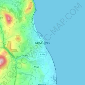
Name: Topografische Karte Greystones, Höhe, Relief.
Durchschnittliche Höhe: 49 m
Minimale Höhe: 0 m
Maximale Höhe: 372 m
Andere topografische Karten
Klicken Sie auf eine Karte, um ihre Topografie, ihre Höhe und ihr Relief anzuzeigen.
Baltinglass
A nineteenth-century explanation is found in Samuel Lewis' A Topographical Dictionary of Ireland, where he says that the name, "according to most antiquaries," comes from Baal-Tin-Glas, meaning the "pure fire of Baal," and that this suggests that the area was a centre for "druidical worship".
Durchschnittliche Höhe: 163 m