Geolokalisieren
👉 Easily get elevation data in JSON, GeoTIFF and KML formats using Elevation API
Vielen Dank für die Unterstützung dieser Website ❤️
Spenden

Topografische Karte Valdallière

Klicken Sie auf die Karte, um die Höhe anzuzeigen.

👉 Easily get elevation data in JSON, GeoTIFF and KML formats using Elevation API
Vielen Dank für die Unterstützung dieser Website ❤️
Spenden

Valdallière

En 2010, le climat de la commune est de type climat océanique franc, selon une étude du CNRS s'appuyant sur une série de données couvrant la période 1971-2000. En 2020, Météo-France publie une typologie des climats de la France métropolitaine dans laquelle la commune est exposée à un climat océanique et est dans la région climatique Normandie (Cotentin, Orne), caractérisée par une pluviométrie relativement élevée (850 mm/a) et un été frais (15,5 °C) et venté. Parallèlement le GIEC normand, un groupe régional d'experts sur le climat, différencie quant à lui, dans une étude de 2020, trois grands types de climats pour la région Normandie, nuancés à une échelle plus fine par les facteurs géographiques locaux. La commune est, selon ce zonage, exposée à un « climat contrasté des collines », correspondant au Bocage normand, bien arrosé, voire très arrosé sur les reliefs les plus exposés au flux d'ouest, et frais en raison de l'altitude.

Wikipedia (CC-BY-SA 3.0)

👉 Easily get elevation data in JSON, GeoTIFF and KML formats using Elevation API
Vielen Dank für die Unterstützung dieser Website ❤️
Spenden

Über diese Karte

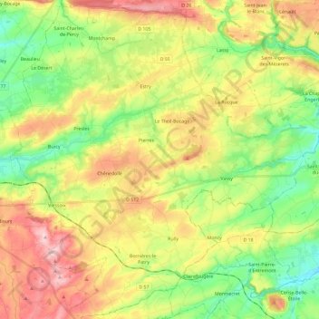
Name: Topografische Karte Valdallière, Höhe, Relief.

Ort: Valdallière, Vire, Calvados, Normandie, France métropolitaine, 14410, France (48.78632 -0.83334 48.93738 -0.60084)

Durchschnittliche Höhe: 191 m

Minimale Höhe: 100 m

Maximale Höhe: 309 m

👉 Easily get elevation data in JSON, GeoTIFF and KML formats using Elevation API
Vielen Dank für die Unterstützung dieser Website ❤️
Spenden

Andere topografische Karten

Klicken Sie auf eine Karte, um ihre Topografie, ihre Höhe und ihr Relief anzuzeigen.

Tailleville

France > Normandie > Calvados

Durchschnittliche Höhe: 36 m

Le Bord du Marais

France > Normandie > Calvados > Canchy

Durchschnittliche Höhe: 11 m

Villa Sayer

France > Normandie > Calvados > Glanville > Lieu Émisse

Durchschnittliche Höhe: 96 m

La Vallée

France > Normandie > Calvados > Mutrécy

Durchschnittliche Höhe: 72 m

Vielen Dank für die Unterstützung dieser Website ❤️
Spenden

Château de Saint-Germain

France > Normandie > Calvados > Marolles

Durchschnittliche Höhe: 150 m

Les Basses Planches

France > Normandie > Calvados > Saint-Omer

Durchschnittliche Höhe: 185 m

Le Pont de la Mousse

France > Normandie > Calvados > Saint-Rémy

Durchschnittliche Höhe: 100 m

Le Val de May

France > Normandie > Calvados > Saint-Martin-de-May > May-sur-Orne

Durchschnittliche Höhe: 49 m

Vielen Dank für die Unterstützung dieser Website ❤️
Spenden

Fumichon

France > Normandie > Calvados > Neuilly-la-Forêt

Durchschnittliche Höhe: 17 m

Secqueville

France > Normandie > Calvados > Le Castelet > Garcelles-Secqueville

Durchschnittliche Höhe: 65 m

Le Launay

France > Normandie > Calvados > Aurseulles

Durchschnittliche Höhe: 126 m

Mont Canisy

France > Normandie > Calvados > Benerville-sur-Mer

Durchschnittliche Höhe: 41 m

Vielen Dank für die Unterstützung dieser Website ❤️
Spenden

La Cinquantaine

France > Normandie > Calvados > Blonville-sur-Mer

Durchschnittliche Höhe: 29 m

Longueville

France > Normandie > Calvados > Ranville

Durchschnittliche Höhe: 18 m

La Garenne

France > Normandie > Calvados > Benerville-sur-Mer

Durchschnittliche Höhe: 21 m

Feuguerolles

France > Normandie > Calvados > Feuguerolles-Bully

Durchschnittliche Höhe: 45 m

Vielen Dank für die Unterstützung dieser Website ❤️
Spenden

La Lamerie

France > Normandie > Calvados > Valdallière

Durchschnittliche Höhe: 218 m

Pointe du Hoc

France > Normandie > Calvados > Cricqueville-en-Bessin

Durchschnittliche Höhe: 11 m

Le Pont de la Landelle

France > Normandie > Calvados > Clécy

Durchschnittliche Höhe: 108 m

Le Moulin Pinel

France > Normandie > Calvados > Souleuvre-en-Bocage > Le Tourneur

Durchschnittliche Höhe: 169 m

Vielen Dank für die Unterstützung dieser Website ❤️
Spenden

La Croix Verte

France > Normandie > Calvados > Valdallière

Durchschnittliche Höhe: 188 m

La Poissonnière

France > Normandie > Calvados > Condé-en-Normandie

Durchschnittliche Höhe: 133 m

Le Lieu Saint-Marc

France > Normandie > Calvados > Le Mesnil-Eudes

Durchschnittliche Höhe: 123 m

Vielen Dank für die Unterstützung dieser Website ❤️
Spenden

Linoudel

France > Normandie > Calvados > Les Monts d'Aunay

Durchschnittliche Höhe: 223 m

L'Aunay

France > Normandie > Calvados > Campagnolles

Durchschnittliche Höhe: 131 m

La Renaudière

France > Normandie > Calvados > Noues de Sienne

Durchschnittliche Höhe: 206 m

Le Val

France > Normandie > Calvados > Saint-Pierre-en-Auge

Durchschnittliche Höhe: 81 m

Vielen Dank für die Unterstützung dieser Website ❤️
Spenden

La Piventière

France > Normandie > Calvados > Saint-Rémy

Durchschnittliche Höhe: 112 m

Les Grandes Haises

France > Normandie > Calvados > Souleuvre-en-Bocage

Durchschnittliche Höhe: 147 m

Mainboeuf

France > Normandie > Calvados > Le Bô

Durchschnittliche Höhe: 143 m

Le Lieu Barbet

France > Normandie > Calvados > Beaumont-en-Auge

Durchschnittliche Höhe: 90 m

Vielen Dank für die Unterstützung dieser Website ❤️
Spenden

Le Carouge

France > Normandie > Calvados > Saint-Léger-Dubosq

Durchschnittliche Höhe: 97 m

La Bourgeoterie

France > Normandie > Calvados > Cambremer

Durchschnittliche Höhe: 107 m

La Fieffe

France > Normandie > Calvados > Le Mesnil-Eudes

Durchschnittliche Höhe: 113 m

Vielen Dank für die Unterstützung dieser Website ❤️
Spenden

Le Vieux Moulin

France > Normandie > Calvados > Le Molay-Littry

Durchschnittliche Höhe: 62 m

Lac du Gast

France > Normandie > Calvados > Noues de Sienne

Durchschnittliche Höhe: 280 m

La Haye

France > Normandie > Calvados > Noues de Sienne

Durchschnittliche Höhe: 226 m

Bures-sur-Dives

France > Normandie > Calvados

Durchschnittliche Höhe: 17 m

Vielen Dank für die Unterstützung dieser Website ❤️
Spenden

Gaumesnil

France > Normandie > Calvados > Cintheaux

Durchschnittliche Höhe: 103 m

Val de Maizet

France > Normandie > Calvados > Maizet

Durchschnittliche Höhe: 72 m

Verson

France > Normandie > Calvados > Verson > Verson

La superficie de la commune est de 1 036 hectares ; l'altitude varie entre 12 et 93 mètres.

Durchschnittliche Höhe: 56 m

Vielen Dank für die Unterstützung dieser Website ❤️
Spenden

Asnelles

France > Normandie > Calvados > Asnelles > Asnelles

Durchschnittliche Höhe: 11 m

Saint-Omer

France > Normandie > Calvados > Saint-Omer > Saint-Omer

Durchschnittliche Höhe: 169 m

Vielen Dank für die Unterstützung dieser Website ❤️
Spenden

Bois de Dozulé

France > Normandie > Calvados > Clermont-en-Auge

Durchschnittliche Höhe: 74 m

La Papillonière

France > Normandie > Calvados > Vire Normandie

Durchschnittliche Höhe: 122 m

Les Champs Rabats

France > Normandie > Calvados > Villers-sur-Mer

Durchschnittliche Höhe: 41 m

Vielen Dank für die Unterstützung dieser Website ❤️
Spenden

La Rue d'Ave

France > Normandie > Calvados > Vignats

Durchschnittliche Höhe: 119 m

Saint-Silly

France > Normandie > Calvados > Thury-Harcourt-le-Hom > Thury-Harcourt

Durchschnittliche Höhe: 91 m

Aunay

France > Normandie > Calvados > Vaux-sur-Aure

Durchschnittliche Höhe: 46 m

Ozane

France > Normandie > Calvados > Coquainvilliers

Durchschnittliche Höhe: 116 m

Vielen Dank für die Unterstützung dieser Website ❤️
Spenden

Le Bas Secron

France > Normandie > Calvados > Maisons

Durchschnittliche Höhe: 33 m

Lieu Malet

France > Normandie > Calvados > Blonville-sur-Mer

Durchschnittliche Höhe: 25 m

La Guinguette

France > Normandie > Calvados > Thue et Mue > Cheux

Durchschnittliche Höhe: 82 m

Moulin de Villers

France > Normandie > Calvados > Villers-Bocage

Durchschnittliche Höhe: 134 m

Vielen Dank für die Unterstützung dieser Website ❤️
Spenden

Le Douit

France > Normandie > Calvados > Valdallière

Durchschnittliche Höhe: 183 m

La Planquette

France > Normandie > Calvados > Littry

Durchschnittliche Höhe: 76 m

Hammeau Goblin

France > Normandie > Calvados > Villers-sur-Mer

Durchschnittliche Höhe: 15 m

Vielen Dank für die Unterstützung dieser Website ❤️
Spenden

Camilly

France > Normandie > Calvados > Le Fresne-Camilly

Durchschnittliche Höhe: 49 m

La Guilmoisière

France > Normandie > Calvados > Vire Normandie

Durchschnittliche Höhe: 242 m

La Butte

France > Normandie > Calvados > Vire Normandie

Durchschnittliche Höhe: 249 m

Creullet

France > Normandie > Calvados > Creully sur Seulles > Creully

Durchschnittliche Höhe: 39 m

Vielen Dank für die Unterstützung dieser Website ❤️
Spenden

Le Beau Moulin

France > Normandie > Calvados > Trévières

Durchschnittliche Höhe: 13 m

Le Pont de la Barre

France > Normandie > Calvados > Trévières

Durchschnittliche Höhe: 25 m

Mont Myrrha

France > Normandie > Calvados > Falaise

Durchschnittliche Höhe: 162 m

La Vigne

France > Normandie > Calvados > Culey-le-Patry

Durchschnittliche Höhe: 136 m

Vielen Dank für die Unterstützung dieser Website ❤️
Spenden

Meulles

France > Normandie > Calvados > Livarot-Pays-d'Auge

Durchschnittliche Höhe: 213 m

Le Moncel

France > Normandie > Calvados > Saint-Pierre-en-Auge > Vaudeloges

Durchschnittliche Höhe: 86 m

Bergogne

France > Normandie > Calvados > Périgny

Durchschnittliche Höhe: 204 m

Ragny

France > Normandie > Calvados > Val d'Arry > Tournay-sur-Odon

Durchschnittliche Höhe: 111 m

Vielen Dank für die Unterstützung dieser Website ❤️
Spenden

La Folie

France > Normandie > Calvados > Moulines

Durchschnittliche Höhe: 145 m

Beauchamp

France > Normandie > Calvados > Moyaux

Durchschnittliche Höhe: 154 m

Favières

France > Normandie > Calvados > Vendeuvre

Durchschnittliche Höhe: 62 m

La Cour à Varin

France > Normandie > Calvados > Douville-en-Auge

Durchschnittliche Höhe: 92 m

Vielen Dank für die Unterstützung dieser Website ❤️
Spenden

La Motte

France > Normandie > Calvados > Cesny-les-Sources

Durchschnittliche Höhe: 162 m

Tainville

France > Normandie > Calvados > Le Molay-Littry

Durchschnittliche Höhe: 53 m

Vielen Dank für die Unterstützung dieser Website ❤️
Spenden

Port Guillaume

France > Normandie > Calvados > Dives-sur-Mer

Durchschnittliche Höhe: 14 m

Le Petit Cagny

France > Normandie > Calvados > Valdallière

Durchschnittliche Höhe: 151 m

Saint-Marc d'Ouilly

France > Normandie > Calvados > Pont-d'Ouilly

Durchschnittliche Höhe: 109 m

Le Haut Chêne

France > Normandie > Calvados > Lison

Durchschnittliche Höhe: 25 m

Vielen Dank für die Unterstützung dieser Website ❤️
Spenden

La Boudehannière

France > Normandie > Calvados > Dialan sur Chaîne > Jurques

Durchschnittliche Höhe: 210 m

La Basse-Bruyère

France > Normandie > Calvados > Amayé-sur-Seulles

Durchschnittliche Höhe: 143 m

Cour de l'École

France > Normandie > Calvados > Livarot-Pays-d'Auge

Durchschnittliche Höhe: 131 m

Lotissement Les Griffons

France > Normandie > Calvados > Falaise

Durchschnittliche Höhe: 149 m

Vielen Dank für die Unterstützung dieser Website ❤️
Spenden

Les Capelles

France > Normandie > Calvados > Blonville-sur-Mer

Durchschnittliche Höhe: 34 m

La Corne

France > Normandie > Calvados > Saint-Pierre-des-Ifs

Durchschnittliche Höhe: 150 m

La Petite Meslière

France > Normandie > Calvados > Le Molay-Littry

Durchschnittliche Höhe: 62 m

Vielen Dank für die Unterstützung dieser Website ❤️
Spenden

Le Bas Mougard

France > Normandie > Calvados > Saint-Paul-du-Vernay

Durchschnittliche Höhe: 65 m

La Route

France > Normandie > Calvados > Val d'Arry > Tournay-sur-Odon

Durchschnittliche Höhe: 135 m

Brettevillette

France > Normandie > Calvados > Val d'Arry > Noyers-Bocage

Durchschnittliche Höhe: 112 m

La Bajonière

France > Normandie > Calvados > Noues de Sienne > Mesnil-Clinchamps

Durchschnittliche Höhe: 169 m

Vielen Dank für die Unterstützung dieser Website ❤️
Spenden