Geolokalisieren
👉 Easily get elevation data in JSON, GeoTIFF and KML formats using Elevation API
Vielen Dank für die Unterstützung dieser Website ❤️
Spenden

Topografische Karte La Croix Verte

Klicken Sie auf die Karte, um die Höhe anzuzeigen.

👉 Easily get elevation data in JSON, GeoTIFF and KML formats using Elevation API
Vielen Dank für die Unterstützung dieser Website ❤️
Spenden

Über diese Karte

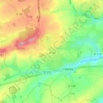
Name: Topografische Karte La Croix Verte, Höhe, Relief.

Ort: La Croix Verte, Vassy, Valdallière, Vire, Calvados, Normandie, France métropolitaine, 14410, France (48.83976 -0.70593 48.87976 -0.66593)

Durchschnittliche Höhe: 188 m

Minimale Höhe: 138 m

Maximale Höhe: 250 m

👉 Easily get elevation data in JSON, GeoTIFF and KML formats using Elevation API
Vielen Dank für die Unterstützung dieser Website ❤️
Spenden

Andere topografische Karten

Klicken Sie auf eine Karte, um ihre Topografie, ihre Höhe und ihr Relief anzuzeigen.

Presles

France > Normandie > Calvados > Valdallière

Durchschnittliche Höhe: 183 m

Le Désert

France > Normandie > Calvados > Valdallière

Durchschnittliche Höhe: 156 m

Viessoix

France > Normandie > Calvados > Valdallière

Durchschnittliche Höhe: 221 m

Château de la Rochelle

France > Normandie > Calvados > Valdallière > Carcel

Durchschnittliche Höhe: 206 m

Vielen Dank für die Unterstützung dieser Website ❤️
Spenden

Estry

France > Normandie > Calvados > Valdallière

Durchschnittliche Höhe: 194 m

Vassy

France > Normandie > Calvados > Valdallière

Durchschnittliche Höhe: 178 m

Pierres

France > Normandie > Calvados > Valdallière

Durchschnittliche Höhe: 204 m

Montchamp

France > Normandie > Calvados > Valdallière

Durchschnittliche Höhe: 196 m

Vielen Dank für die Unterstützung dieser Website ❤️
Spenden

Burcy

France > Normandie > Calvados > Valdallière

Durchschnittliche Höhe: 178 m