
Spenden
Topografische Karte St. Walburg
Klicken Sie auf die Karte, um die Höhe anzuzeigen.
Spenden
Über diese Karte
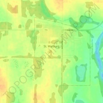
Name: Topografische Karte St. Walburg, Höhe, Relief.
Ort: St. Walburg, Saskatchewan, S0M 2T0, Canada (53.62064 -109.21232 53.63850 -109.18776)
Durchschnittliche Höhe: 642 m
Minimale Höhe: 622 m
Maximale Höhe: 654 m
Spenden
Andere topografische Karten
Klicken Sie auf eine Karte, um ihre Topografie, ihre Höhe und ihr Relief anzuzeigen.
Valley Centre
Canada > Saskatchewan > Division No. 12 > Marriott No. 317
Durchschnittliche Höhe: 602 m
Spenden
Spenden
Whitecap Dakota First Nation
Canada > Saskatchewan > Whitecap Dakota First Nation
Durchschnittliche Höhe: 495 m
Morin Lake
Canada > Saskatchewan > Northern Saskatchewan Administration District > Morin Lake
Durchschnittliche Höhe: 385 m
Spenden
Black Lake
Canada > Saskatchewan > Northern Saskatchewan Administration District > Black Lake
Durchschnittliche Höhe: 293 m
Spenden
Spenden
La Loche
Canada > Saskatchewan > Northern Saskatchewan Administration District > La Loche
Durchschnittliche Höhe: 447 m
Waterloo Lake
Canada > Saskatchewan > Northern Saskatchewan Administration District
Durchschnittliche Höhe: 286 m
Spenden
Air Ronge
Canada > Saskatchewan > Northern Saskatchewan Administration District > Air Ronge
Durchschnittliche Höhe: 369 m
Garson Lake
Canada > Saskatchewan > Northern Saskatchewan Administration District > Garson Lake
Durchschnittliche Höhe: 470 m
Stony Rapids
Canada > Saskatchewan > Northern Saskatchewan Administration District
Durchschnittliche Höhe: 227 m
Spenden
Hall Lake
Canada > Saskatchewan > Northern Saskatchewan Administration District > Hall Lake
Durchschnittliche Höhe: 391 m
Zeden Lake
Canada > Saskatchewan > Northern Saskatchewan Administration District
Durchschnittliche Höhe: 526 m
Spenden