
Spenden
Topografische Karte Stony Rapids
Klicken Sie auf die Karte, um die Höhe anzuzeigen.
Spenden
Über diese Karte
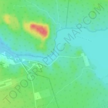
Name: Topografische Karte Stony Rapids, Höhe, Relief.
Durchschnittliche Höhe: 227 m
Minimale Höhe: 209 m
Maximale Höhe: 272 m
Spenden
Andere topografische Karten
Klicken Sie auf eine Karte, um ihre Topografie, ihre Höhe und ihr Relief anzuzeigen.
Morin Lake
Canada > Saskatchewan > Northern Saskatchewan Administration District > Morin Lake
Durchschnittliche Höhe: 385 m
Black Lake
Canada > Saskatchewan > Northern Saskatchewan Administration District > Black Lake
Durchschnittliche Höhe: 293 m
La Loche
Canada > Saskatchewan > Northern Saskatchewan Administration District > La Loche
Durchschnittliche Höhe: 447 m
Air Ronge
Canada > Saskatchewan > Northern Saskatchewan Administration District > Air Ronge
Durchschnittliche Höhe: 369 m
Spenden
Garson Lake
Canada > Saskatchewan > Northern Saskatchewan Administration District > Garson Lake
Durchschnittliche Höhe: 470 m
Hall Lake
Canada > Saskatchewan > Northern Saskatchewan Administration District > Hall Lake
Durchschnittliche Höhe: 391 m
Doré Lake
Canada > Saskatchewan > Northern Saskatchewan Administration District
Durchschnittliche Höhe: 475 m