
Topografische Karte Neal
Interaktive Karte
Klicken Sie auf die Karte, um die Höhe anzuzeigen.
Über diese Karte
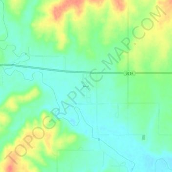
Name: Topografische Karte Neal, Höhe, Relief.
Ort: Neal, Greenwood County, Kansas, 66863, United States (37.81420 -96.10027 37.85420 -96.06027)
Durchschnittliche Höhe: 305 m
Minimale Höhe: 284 m
Maximale Höhe: 341 m
Andere topografische Karten
Klicken Sie auf eine Karte, um ihre Topografie, ihre Höhe und ihr Relief anzuzeigen.
Madison
United States > Kansas > Greenwood County
Madison, Greenwood County, Kansas, 66860, United States
Durchschnittliche Höhe: 347 m
Eureka
United States > Kansas > Greenwood County
Eureka, Greenwood County, Kansas, 67045, United States
Durchschnittliche Höhe: 341 m
Piedmont
United States > Kansas > Greenwood County
Piedmont, Greenwood County, Kansas, 67122, United States
Durchschnittliche Höhe: 375 m
Virgil
United States > Kansas > Greenwood County
Virgil, Greenwood County, Kansas, 66870, United States
Durchschnittliche Höhe: 309 m
Severy
United States > Kansas > Greenwood County
Severy, Greenwood County, Kansas, 67137, United States
Durchschnittliche Höhe: 338 m
Climax
United States > Kansas > Greenwood County
Climax, Greenwood County, Kansas, United States
Durchschnittliche Höhe: 313 m
Hamilton
United States > Kansas > Greenwood County
Hamilton, Greenwood County, Kansas, 66853, United States
Durchschnittliche Höhe: 338 m
Fall River
United States > Kansas > Greenwood County
Fall River, Greenwood County, Kansas, 67047, United States
Durchschnittliche Höhe: 291 m
Quincy
United States > Kansas > Greenwood County > Quincy
Quincy, Greenwood County, Kansas, United States
Durchschnittliche Höhe: 294 m
Temple Knob
United States > Kansas > Greenwood County
Temple Knob, Greenwood County, Kansas, United States
Durchschnittliche Höhe: 460 m