
Topografische Karte Climax
Interaktive Karte
Klicken Sie auf die Karte, um die Höhe anzuzeigen.
Über diese Karte
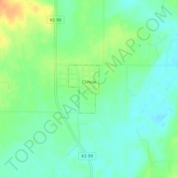
Name: Topografische Karte Climax, Höhe, Relief.
Ort: Climax, Greenwood County, Kansas, United States (37.71497 -96.22728 37.72230 -96.22137)
Durchschnittliche Höhe: 313 m
Minimale Höhe: 299 m
Maximale Höhe: 339 m
Climax was founded in 1884. It was named from its elevation, or Climax College in Kalamazoo, Michigan.
Andere topografische Karten
Klicken Sie auf eine Karte, um ihre Topografie, ihre Höhe und ihr Relief anzuzeigen.
Madison
United States > Kansas > Greenwood County
Madison, Greenwood County, Kansas, 66860, United States
Durchschnittliche Höhe: 347 m
Eureka
United States > Kansas > Greenwood County
Eureka, Greenwood County, Kansas, 67045, United States
Durchschnittliche Höhe: 341 m
Piedmont
United States > Kansas > Greenwood County
Piedmont, Greenwood County, Kansas, 67122, United States
Durchschnittliche Höhe: 375 m
Virgil
United States > Kansas > Greenwood County
Virgil, Greenwood County, Kansas, 66870, United States
Durchschnittliche Höhe: 309 m
Severy
United States > Kansas > Greenwood County
Severy, Greenwood County, Kansas, 67137, United States
Durchschnittliche Höhe: 338 m
Neal
United States > Kansas > Greenwood County
Neal, Greenwood County, Kansas, 66863, United States
Durchschnittliche Höhe: 305 m
Hamilton
United States > Kansas > Greenwood County
Hamilton, Greenwood County, Kansas, 66853, United States
Durchschnittliche Höhe: 338 m
Fall River
United States > Kansas > Greenwood County
Fall River, Greenwood County, Kansas, 67047, United States
Durchschnittliche Höhe: 291 m
Quincy
United States > Kansas > Greenwood County > Quincy
Quincy, Greenwood County, Kansas, United States
Durchschnittliche Höhe: 294 m
Temple Knob
United States > Kansas > Greenwood County
Temple Knob, Greenwood County, Kansas, United States
Durchschnittliche Höhe: 460 m