
Topografische Karte John Day
Interaktive Karte
Klicken Sie auf die Karte, um die Höhe anzuzeigen.
Über diese Karte
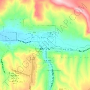
Name: Topografische Karte John Day, Höhe, Relief.
Ort: John Day, Grant County, Oregon, 97845, United States (44.40318 -118.98629 44.43233 -118.91518)
Durchschnittliche Höhe: 1.047 m
Minimale Höhe: 918 m
Maximale Höhe: 1.254 m
John Day is at an elevation of 3,087 feet (941 m). According to the United States Census Bureau, the city has a total area of 1.87 square miles (4.84 km2), all land.
Andere topografische Karten
Klicken Sie auf eine Karte, um ihre Topografie, ihre Höhe und ihr Relief anzuzeigen.
Granite
United States > Oregon > Grant County
Granite, Grant County, Oregon, United States
Durchschnittliche Höhe: 1.475 m
Robinsonville
United States > Oregon > Grant County
Robinsonville, Grant County, Oregon, United States
Durchschnittliche Höhe: 1.858 m
Austin
United States > Oregon > Grant County
Austin, Grant County, Oregon, United States
Durchschnittliche Höhe: 1.312 m
Monument
United States > Oregon > Grant County
Monument, Grant County, Oregon, United States
Durchschnittliche Höhe: 640 m
Kimberly
United States > Oregon > Grant County
Kimberly, Grant County, Oregon, United States
Durchschnittliche Höhe: 711 m
Desolation Butte
United States > Oregon > Grant County
Desolation Butte, Grant County, Oregon, United States
Durchschnittliche Höhe: 1.949 m
Rabbit Ears
United States > Oregon > Grant County
Rabbit Ears, Grant County, Oregon, United States
Durchschnittliche Höhe: 2.285 m
Canyon City
United States > Oregon > Grant County
Canyon City, Grant County, Oregon, 97820, United States
Durchschnittliche Höhe: 1.078 m
Prairie City
United States > Oregon > Grant County > Prairie City
Prairie City, Grant County, Oregon, United States
Durchschnittliche Höhe: 1.104 m