
Topografische Karte Canyon City
Interaktive Karte
Klicken Sie auf die Karte, um die Höhe anzuzeigen.
Über diese Karte
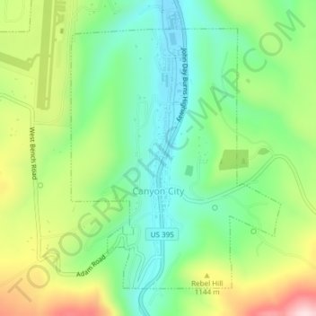
Name: Topografische Karte Canyon City, Höhe, Relief.
Ort: Canyon City, Grant County, Oregon, 97820, United States (44.38124 -118.96065 44.40346 -118.93560)
Durchschnittliche Höhe: 1.078 m
Minimale Höhe: 955 m
Maximale Höhe: 1.293 m
The city is at an elevation of about 3,200 feet (980 m). Between Canyon City and Burns, to the south, Route 395 passes through parts of the Malheur National Forest. According to the United States Census Bureau, the town has a total area of 1.41 square miles (3.65 km2), all land.
Andere topografische Karten
Klicken Sie auf eine Karte, um ihre Topografie, ihre Höhe und ihr Relief anzuzeigen.
Granite
United States > Oregon > Grant County
Granite, Grant County, Oregon, United States
Durchschnittliche Höhe: 1.475 m
Robinsonville
United States > Oregon > Grant County
Robinsonville, Grant County, Oregon, United States
Durchschnittliche Höhe: 1.858 m
Austin
United States > Oregon > Grant County
Austin, Grant County, Oregon, United States
Durchschnittliche Höhe: 1.312 m
Monument
United States > Oregon > Grant County
Monument, Grant County, Oregon, United States
Durchschnittliche Höhe: 640 m
Kimberly
United States > Oregon > Grant County
Kimberly, Grant County, Oregon, United States
Durchschnittliche Höhe: 711 m
John Day
United States > Oregon > Grant County
John Day, Grant County, Oregon, 97845, United States
Durchschnittliche Höhe: 1.047 m
Desolation Butte
United States > Oregon > Grant County
Desolation Butte, Grant County, Oregon, United States
Durchschnittliche Höhe: 1.949 m
Rabbit Ears
United States > Oregon > Grant County
Rabbit Ears, Grant County, Oregon, United States
Durchschnittliche Höhe: 2.285 m
Prairie City
United States > Oregon > Grant County > Prairie City
Prairie City, Grant County, Oregon, United States
Durchschnittliche Höhe: 1.104 m