
Topografische Karte Lichfield
Klicken Sie auf die Karte, um die Höhe anzuzeigen.
Über diese Karte
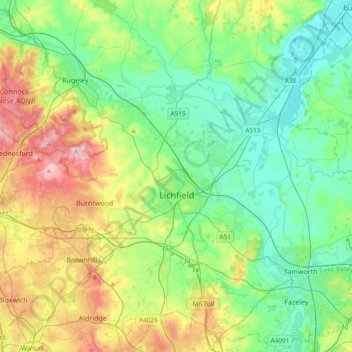
Name: Topografische Karte Lichfield, Höhe, Relief.
Ort: Lichfield, Staffordshire, England, United Kingdom (52.58489 -1.96323 52.80779 -1.58629)
Durchschnittliche Höhe: 103 m
Minimale Höhe: 43 m
Maximale Höhe: 241 m
Andere topografische Karten
Klicken Sie auf eine Karte, um ihre Topografie, ihre Höhe und ihr Relief anzuzeigen.
Rudyard Lake
United Kingdom > England > Staffordshire > Staffordshire Moorlands > Rudyard > Horton
Durchschnittliche Höhe: 205 m
Blithfield Reservoir
United Kingdom > England > Staffordshire > East Staffordshire > Admaston
Durchschnittliche Höhe: 108 m
Talke Pits
United Kingdom > England > Staffordshire > Newcastle-under-Lyme > Talke
Durchschnittliche Höhe: 179 m
College Gardens
United Kingdom > England > Staffordshire > Newcastle-under-Lyme > Madeley
Durchschnittliche Höhe: 123 m
Wombourne
United Kingdom > England > Staffordshire > South Staffordshire
Durchschnittliche Höhe: 106 m
Tutbury Castle
United Kingdom > England > Staffordshire > East Staffordshire > Tutbury
Durchschnittliche Höhe: 66 m
Burton upon Trent
United Kingdom > England > Staffordshire > East Staffordshire
Burton is about 109 miles (175 km) north west of London, about 30 miles north east of Birmingham, the UK's second largest city and about 23 miles east of the county town Stafford. It is at the easternmost border of the county of Staffordshire with Derbyshire, its suburbs and the course of the River Trent…
Durchschnittliche Höhe: 69 m
Werrington
United Kingdom > England > Staffordshire > Staffordshire Moorlands
Durchschnittliche Höhe: 229 m
Stubwood
United Kingdom > England > Staffordshire > East Staffordshire > Denstone
Durchschnittliche Höhe: 113 m
Birch Cross
United Kingdom > England > Staffordshire > East Staffordshire > Marchington
Durchschnittliche Höhe: 92 m
Huntington
United Kingdom > England > Staffordshire > South Staffordshire
Durchschnittliche Höhe: 166 m
Biddulph Moor
United Kingdom > England > Staffordshire > Staffordshire Moorlands
Durchschnittliche Höhe: 242 m
Wain Lea
United Kingdom > England > Staffordshire > Newcastle-under-Lyme > Harriseahead
Durchschnittliche Höhe: 207 m
Fauld
United Kingdom > England > Staffordshire > East Staffordshire > Hanbury
Durchschnittliche Höhe: 88 m
Weston Park
United Kingdom > England > Staffordshire > South Staffordshire > Weston under Lizard
Durchschnittliche Höhe: 113 m
Pattingham
United Kingdom > England > Staffordshire > South Staffordshire
Durchschnittliche Höhe: 106 m
Coppenhall
United Kingdom > England > Staffordshire > South Staffordshire
Durchschnittliche Höhe: 104 m
Hademore
United Kingdom > England > Staffordshire > Lichfield > Whittington
Durchschnittliche Höhe: 67 m
Stepping Stones
United Kingdom > England > Staffordshire > Staffordshire Moorlands
Durchschnittliche Höhe: 224 m
Bottomhouse
United Kingdom > England > Staffordshire > Staffordshire Moorlands > Ipstones
Durchschnittliche Höhe: 312 m
Apedale
United Kingdom > England > Staffordshire > Newcastle-under-Lyme > Chesterton
Durchschnittliche Höhe: 168 m
Levedale
United Kingdom > England > Staffordshire > South Staffordshire > Penkridge
Durchschnittliche Höhe: 98 m
Roughcote
United Kingdom > England > Staffordshire > Staffordshire Moorlands > Caverswall
Durchschnittliche Höhe: 217 m
Bradwell
United Kingdom > England > Staffordshire > Newcastle-under-Lyme
Durchschnittliche Höhe: 153 m
Blackshaw Moor
United Kingdom > England > Staffordshire > Staffordshire Moorlands > Thorncliffe
Durchschnittliche Höhe: 282 m
Castle Ring
United Kingdom > England > Staffordshire > Cannock Chase > Cannock Wood
It is the highest point on The Chase with an elevation of 242 metres (794 ft).
Durchschnittliche Höhe: 191 m
Wolstanton
United Kingdom > England > Staffordshire > Newcastle-under-Lyme
Durchschnittliche Höhe: 144 m
Himley
United Kingdom > England > Staffordshire > South Staffordshire > Himley
Durchschnittliche Höhe: 96 m
Newcastle-under-Lyme
United Kingdom > England > Staffordshire > Newcastle-under-Lyme
Durchschnittliche Höhe: 147 m
Bignall End
United Kingdom > England > Staffordshire > Newcastle-under-Lyme > Audley
Durchschnittliche Höhe: 150 m
Endon Bank
United Kingdom > England > Staffordshire > Staffordshire Moorlands > Endon
Durchschnittliche Höhe: 192 m
Bednall
United Kingdom > England > Staffordshire > South Staffordshire > Bednall
Durchschnittliche Höhe: 118 m
Halfpenny Green
United Kingdom > England > Staffordshire > South Staffordshire
Durchschnittliche Höhe: 91 m
Lower Lee
United Kingdom > England > Staffordshire > Staffordshire Moorlands > Meerbrook > Lower Lee
Durchschnittliche Höhe: 264 m
Betley Mere
United Kingdom > England > Staffordshire > Borough of Newcastle-under-Lyme > Wrinehill > Cracow Moss
Durchschnittliche Höhe: 81 m
Oakamoor
United Kingdom > England > Staffordshire > Staffordshire Moorlands
Durchschnittliche Höhe: 191 m
Ashley Heath
United Kingdom > England > Staffordshire > Newcastle-under-Lyme
Durchschnittliche Höhe: 192 m
Horton
United Kingdom > England > Staffordshire > Staffordshire Moorlands > Gratton
Durchschnittliche Höhe: 199 m
Acton Trussell
United Kingdom > England > Staffordshire > South Staffordshire
Durchschnittliche Höhe: 93 m
Merryton Low
United Kingdom > England > Staffordshire > Staffordshire Moorlands
Durchschnittliche Höhe: 412 m
Wood Lane
United Kingdom > England > Staffordshire > Newcastle-under-Lyme > Bignall Hill
Durchschnittliche Höhe: 168 m
Rushton Spencer
United Kingdom > England > Staffordshire > Staffordshire Moorlands
Durchschnittliche Höhe: 204 m
Calf Heath
United Kingdom > England > Staffordshire > South Staffordshire > Hatherton Junction
Durchschnittliche Höhe: 113 m
Chasewater
United Kingdom > England > Staffordshire > Lichfield > Burntwood > Chasetown
Durchschnittliche Höhe: 155 m
Ash Bank
United Kingdom > England > Staffordshire > Staffordshire Moorlands
Durchschnittliche Höhe: 195 m
Hednesford Hills
United Kingdom > England > Staffordshire > Cannock Chase
Durchschnittliche Höhe: 194 m
Wetley Rocks
United Kingdom > England > Staffordshire > Staffordshire Moorlands
Durchschnittliche Höhe: 229 m
Old Hannah's Hole
United Kingdom > England > Staffordshire > Staffordshire Moorlands > Wetton
Durchschnittliche Höhe: 276 m
Milk Hill
United Kingdom > England > Staffordshire > Staffordshire Moorlands
Durchschnittliche Höhe: 274 m
Cauldon
United Kingdom > England > Staffordshire > Staffordshire Moorlands
Durchschnittliche Höhe: 282 m
Moneystone
United Kingdom > England > Staffordshire > Staffordshire Moorlands > Cotton
Durchschnittliche Höhe: 231 m
Mucklestone
United Kingdom > England > Staffordshire > Newcastle-under-Lyme
Durchschnittliche Höhe: 143 m
Biddulph Grange Country Park
United Kingdom > England > Staffordshire > Staffordshire Moorlands > Biddulph > Biddulph Moor
Durchschnittliche Höhe: 229 m
Moneystone Quarry
United Kingdom > England > Staffordshire > Staffordshire Moorlands > Kingsley > Whiston Eaves
Durchschnittliche Höhe: 202 m
Hales Hall Pool
United Kingdom > England > Staffordshire > Staffordshire Moorlands > Cheadle
Durchschnittliche Höhe: 182 m
Red Street
United Kingdom > England > Staffordshire > Newcastle-under-Lyme
Durchschnittliche Höhe: 171 m
Mottey Meadows NNR
United Kingdom > England > Staffordshire > South Staffordshire > Wheaton Aston
Durchschnittliche Höhe: 110 m
Brown Edge
United Kingdom > England > Staffordshire > Staffordshire Moorlands
Durchschnittliche Höhe: 197 m
Whiston
United Kingdom > England > Staffordshire > South Staffordshire > Penkridge
Durchschnittliche Höhe: 95 m
Cellarhead
United Kingdom > England > Staffordshire > Staffordshire Moorlands
Durchschnittliche Höhe: 240 m
Whitmore Heath
United Kingdom > England > Staffordshire > Newcastle-under-Lyme > Whitmore
Durchschnittliche Höhe: 141 m
Hempstalls
United Kingdom > England > Staffordshire > Newcastle-under-Lyme
Durchschnittliche Höhe: 141 m
Birks Wood
United Kingdom > England > Staffordshire > Newcastle-under-Lyme > Shraleybrook
Durchschnittliche Höhe: 109 m
Gratwich
United Kingdom > England > Staffordshire > East Staffordshire > Kingstone
Durchschnittliche Höhe: 143 m
Lower Penn
United Kingdom > England > Staffordshire > South Staffordshire
Durchschnittliche Höhe: 114 m
Gospel End
United Kingdom > England > Staffordshire > South Staffordshire
Durchschnittliche Höhe: 158 m
Hope
United Kingdom > England > Staffordshire > Staffordshire Moorlands > Alstonefield
Durchschnittliche Höhe: 274 m
Burgess Brook
United Kingdom > England > Staffordshire > Newcastle-under-Lyme
Durchschnittliche Höhe: 149 m