
Topografische Karte Texas
Interaktive Karte
Klicken Sie auf die Karte, um die Höhe anzuzeigen.
Über diese Karte
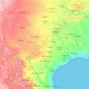
Name: Topografische Karte Texas, Höhe, Relief.
Ort: Texas, United States of America (25.83706 -106.64585 36.50045 -93.50782)
Durchschnittliche Höhe: 641 m
Minimale Höhe: -2 m
Maximale Höhe: 3.767 m
With 10 climatic regions, 14 soil regions and 11 distinct ecological regions, regional classification becomes problematic with differences in soils, topography, geology, rainfall, and plant and animal communities. One classification system divides Texas, in order from southeast to west, into the following: Gulf Coastal Plains, Interior Lowlands, Great Plains, and Basin and Range Province.
Andere topografische Karten
Klicken Sie auf eine Karte, um ihre Topografie, ihre Höhe und ihr Relief anzuzeigen.
Washington County
United States of America > Texas
Washington County, Texas, United States of America
Durchschnittliche Höhe: 87 m
Jackson County
United States of America > Texas
Jackson County, Texas, United States of America
Durchschnittliche Höhe: 22 m
Marion County
United States of America > Texas
Marion County, Texas, 75657, United States of America
Durchschnittliche Höhe: 87 m
King County
United States of America > Texas
King County, Texas, 79236, United States of America
Durchschnittliche Höhe: 540 m
Andrews County
United States of America > Texas
Andrews County, Texas, 79714, United States of America
Durchschnittliche Höhe: 965 m