
Topografische Karte King County
Interaktive Karte
Klicken Sie auf die Karte, um die Höhe anzuzeigen.
Über diese Karte
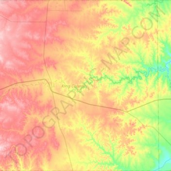
Name: Topografische Karte King County, Höhe, Relief.
Ort: King County, Texas, 79236, United States of America (33.39699 -100.51864 33.83599 -99.99095)
Durchschnittliche Höhe: 540 m
Minimale Höhe: 434 m
Maximale Höhe: 654 m
Andere topografische Karten
Klicken Sie auf eine Karte, um ihre Topografie, ihre Höhe und ihr Relief anzuzeigen.
Washington County
United States of America > Texas
Washington County, Texas, United States of America
Durchschnittliche Höhe: 87 m
Jackson County
United States of America > Texas
Jackson County, Texas, United States of America
Durchschnittliche Höhe: 22 m
Marion County
United States of America > Texas
Marion County, Texas, 75657, United States of America
Durchschnittliche Höhe: 87 m
Andrews County
United States of America > Texas
Andrews County, Texas, 79714, United States of America
Durchschnittliche Höhe: 965 m