
Spenden
Topografische Karte Limerick City
Klicken Sie auf die Karte, um die Höhe anzuzeigen.
Spenden
Über diese Karte
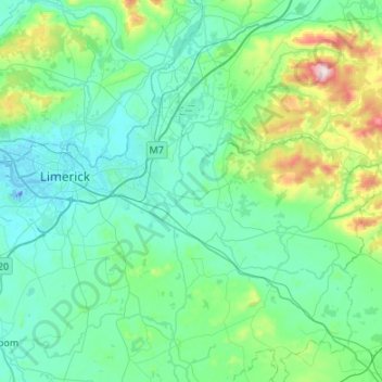
Name: Topografische Karte Limerick City, Höhe, Relief.
Ort: Limerick City, County Limerick, Munster, Ireland (52.53981 -8.72616 52.75738 -8.18786)
Durchschnittliche Höhe: 102 m
Minimale Höhe: -26 m
Maximale Höhe: 690 m
Spenden
Andere topografische Karten
Klicken Sie auf eine Karte, um ihre Topografie, ihre Höhe und ihr Relief anzuzeigen.
Kilcruaig
Ireland > County Limerick > The Municipal District of Cappamore — Kilmallock
Durchschnittliche Höhe: 200 m
Knockadea
Ireland > County Limerick > The Municipal District of Cappamore — Kilmallock
Durchschnittliche Höhe: 203 m
Pallasgreen
Ireland > County Limerick > The Municipal District of Cappamore — Kilmallock
Durchschnittliche Höhe: 72 m
Galtymore
Ireland > County Limerick > The Municipal District of Cappamore — Kilmallock
Galtymore or Galteemore (Irish: Cnoc Mór na nGaibhlte, meaning 'big hill of the Galtees') is a mountain in the province of Munster, Ireland. At 917.9 metres (3,011 ft 6 in), it is one of Ireland's highest mountains, being the 12th-highest on the Arderin list, and 14th-highest on the Vandeleur-Lynam list.…
Durchschnittliche Höhe: 594 m
Spenden
Aherlow
Ireland > County Limerick > The Municipal District of Cappamore — Kilmallock
Durchschnittliche Höhe: 141 m
Limerick
Ireland > County Limerick > Limerick
Limerick's climate is classified as temperate oceanic (Köppen Cfb). Met Éireann maintains a climatological weather station at Shannon Airport, 20 kilometres west of the city in County Clare. Shannon Airport records an average of 977 millimetres of precipitation annually, most of which is rain. Limerick has a…
Durchschnittliche Höhe: 10 m
Clare Glens
Ireland > County Limerick > The Municipal District of Cappamore — Kilmallock
Durchschnittliche Höhe: 124 m
Spenden
Knockawarriga
Ireland > County Limerick > The Municipal District of Newcastle West
Durchschnittliche Höhe: 247 m
Crecora
Ireland > County Limerick > The Municipal District of Adare — Rathkeale
Durchschnittliche Höhe: 37 m
Bleach Lough
Ireland > County Limerick > The Municipal District of Adare — Rathkeale
Durchschnittliche Höhe: 10 m
Ardpatrick
Ireland > County Limerick > The Municipal District of Cappamore — Kilmallock
Durchschnittliche Höhe: 169 m
Spenden
Templeglantine
Ireland > County Limerick > The Municipal District of Newcastle West
Durchschnittliche Höhe: 189 m
Bruff
Ireland > County Limerick > The Municipal District of Cappamore — Kilmallock
Durchschnittliche Höhe: 68 m
Spenden
Bruree
Ireland > County Limerick > The Municipal District of Cappamore — Kilmallock
Durchschnittliche Höhe: 62 m
Thomond Village Student Accommodation
Ireland > County Limerick > Limerick
Durchschnittliche Höhe: 8 m
Deel
Ireland > County Limerick > The Municipal District of Adare — Rathkeale
Durchschnittliche Höhe: 25 m
Croom
Ireland > County Limerick > The Municipal District of Adare — Rathkeale > Croom
Durchschnittliche Höhe: 34 m
Spenden
Tory Hill
Ireland > County Limerick > The Municipal District of Adare — Rathkeale
Durchschnittliche Höhe: 35 m
Thomond Village Student Accommodation
Ireland > County Limerick > Limerick
Durchschnittliche Höhe: 8 m
Spenden