
Topografische Karte la Vall de Boí
Interaktive Karte
Klicken Sie auf die Karte, um die Höhe anzuzeigen.
la Vall de Boí
The small town of Durro is situated at an elevation of 1,386 metres, on a south-facing mountainside. The church has a single long and narrow nave with a barrel vault and slate roof. It was built with a single apse, now replaced by a sacristy. Two square chapels have been built into the northern wall, and the bell tower rises from the northeast corner to five storeys. The entrance is cut into the southern wall, to a covered walkway. The building has been renovated and extended many times since it was built in the 12th century and little of its original appearance remains. The interior retains Baroque features from later renovations.
Über diese Karte
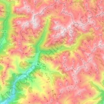
Name: Topografische Karte la Vall de Boí, Höhe, Relief.
Ort: la Vall de Boí, Alta Ribagorça, Lleida, Catalonia, Spain (42.45411 0.73941 42.63191 0.97266)
Durchschnittliche Höhe: 2.141 m
Minimale Höhe: 936 m
Maximale Höhe: 2.989 m
Andere topografische Karten
Klicken Sie auf eine Karte, um ihre Topografie, ihre Höhe und ihr Relief anzuzeigen.
Taüll
Spain > Catalonia > Alta Ribagorça > la Vall de Boí
Located at an altitude of 1,520 meters in the Sant Martí valley, a small valley in the Valley of Boí. The closest river is the Sant Martí river, Noguera de Tor affluent. A ravine splits the village in two districts: La Guinsa and Lo Barri. La Guinsa goes from the entrance of the village to the ravine, and…
Durchschnittliche Höhe: 1.707 m