
Topografische Karte Densole
Interaktive Karte
Klicken Sie auf die Karte, um die Höhe anzuzeigen.
Über diese Karte
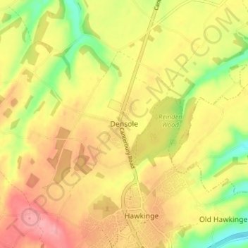
Name: Topografische Karte Densole, Höhe, Relief.
Durchschnittliche Höhe: 146 m
Minimale Höhe: 89 m
Maximale Höhe: 189 m
Andere topografische Karten
Klicken Sie auf eine Karte, um ihre Topografie, ihre Höhe und ihr Relief anzuzeigen.
Hythe
United Kingdom > England > Kent > Folkestone and Hythe District
Hythe, Folkestone and Hythe District, Kent, England, United Kingdom
Durchschnittliche Höhe: 32 m
Folkestone
United Kingdom > England > Kent > Folkestone and Hythe District
Folkestone, Folkestone and Hythe District, Kent, England, United Kingdom
Durchschnittliche Höhe: 62 m
Park Gate
United Kingdom > England > Kent > Folkestone and Hythe District > Elham
Park Gate, Elham, Folkestone and Hythe District, Kent, England, CT4 6BH, United Kingdom
Durchschnittliche Höhe: 130 m
Lympne
United Kingdom > England > Kent > Folkestone and Hythe District
Lympne, Folkestone and Hythe District, Kent, England, United Kingdom
Durchschnittliche Höhe: 56 m
Littlestone on Sea
United Kingdom > England > Kent > Folkestone and Hythe District > New Romney
Littlestone on Sea, New Romney, Folkestone and Hythe District, Kent, England, TN28 8QU, United Kingdom
Durchschnittliche Höhe: 1 m