Geolokalisieren

Topografische Karte Hythe

Interaktive Karte

Klicken Sie auf die Karte, um die Höhe anzuzeigen.

Über diese Karte

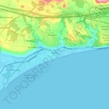
Name: Topografische Karte Hythe, Höhe, Relief.

Ort: Hythe, Folkestone and Hythe District, Kent, England, United Kingdom (51.04664 1.02214 51.08961 1.12895)

Durchschnittliche Höhe: 32 m

Minimale Höhe: -2 m

Maximale Höhe: 165 m

Andere topografische Karten

Klicken Sie auf eine Karte, um ihre Topografie, ihre Höhe und ihr Relief anzuzeigen.

Folkestone

United Kingdom > England > Kent > Folkestone and Hythe District

Folkestone, Folkestone and Hythe District, Kent, England, United Kingdom

Durchschnittliche Höhe: 62 m

Park Gate

United Kingdom > England > Kent > Folkestone and Hythe District > Elham

Park Gate, Elham, Folkestone and Hythe District, Kent, England, CT4 6BH, United Kingdom

Durchschnittliche Höhe: 130 m

Lympne

United Kingdom > England > Kent > Folkestone and Hythe District

Lympne, Folkestone and Hythe District, Kent, England, United Kingdom

Durchschnittliche Höhe: 56 m

Littlestone on Sea

United Kingdom > England > Kent > Folkestone and Hythe District > New Romney

Littlestone on Sea, New Romney, Folkestone and Hythe District, Kent, England, TN28 8QU, United Kingdom

Durchschnittliche Höhe: 1 m

Densole

United Kingdom > England > Kent > Folkestone and Hythe District

Densole, Folkestone and Hythe District, Kent, England, CT18 7BE, United Kingdom

Durchschnittliche Höhe: 146 m