
Topografische Karte White City
Interaktive Karte
Klicken Sie auf die Karte, um die Höhe anzuzeigen.
Über diese Karte
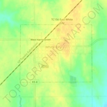
Name: Topografische Karte White City, Höhe, Relief.
Ort: White City, Morris County, Kansas, United States (38.78661 -96.74672 38.80118 -96.72331)
Durchschnittliche Höhe: 444 m
Minimale Höhe: 427 m
Maximale Höhe: 455 m
Andere topografische Karten
Klicken Sie auf eine Karte, um ihre Topografie, ihre Höhe und ihr Relief anzuzeigen.
Dwight
United States > Kansas > Morris County
Dwight, Morris County, Kansas, 66849, United States
Durchschnittliche Höhe: 457 m
Council Grove Lake
United States > Kansas > Morris County
Council Grove Lake, Morris County, Kansas, United States
Durchschnittliche Höhe: 400 m
Parkerville
United States > Kansas > Morris County
Parkerville, Morris County, Kansas, United States
Durchschnittliche Höhe: 422 m
Council Grove
United States > Kansas > Morris County > Council Grove
Council Grove, Morris County, Kansas, United States
Durchschnittliche Höhe: 389 m
Wilsey
United States > Kansas > Morris County
Wilsey, Morris County, Kansas, United States
Durchschnittliche Höhe: 459 m