
Topografische Karte Dwight
Interaktive Karte
Klicken Sie auf die Karte, um die Höhe anzuzeigen.
Über diese Karte
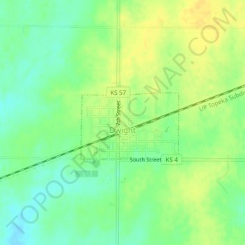
Name: Topografische Karte Dwight, Höhe, Relief.
Ort: Dwight, Morris County, Kansas, 66849, United States (38.84116 -96.59926 38.84929 -96.58539)
Durchschnittliche Höhe: 457 m
Minimale Höhe: 444 m
Maximale Höhe: 469 m
Andere topografische Karten
Klicken Sie auf eine Karte, um ihre Topografie, ihre Höhe und ihr Relief anzuzeigen.
White City
United States > Kansas > Morris County
White City, Morris County, Kansas, United States
Durchschnittliche Höhe: 444 m
Council Grove Lake
United States > Kansas > Morris County
Council Grove Lake, Morris County, Kansas, United States
Durchschnittliche Höhe: 400 m
Parkerville
United States > Kansas > Morris County
Parkerville, Morris County, Kansas, United States
Durchschnittliche Höhe: 422 m
Council Grove
United States > Kansas > Morris County > Council Grove
Council Grove, Morris County, Kansas, United States
Durchschnittliche Höhe: 389 m
Wilsey
United States > Kansas > Morris County
Wilsey, Morris County, Kansas, United States
Durchschnittliche Höhe: 459 m